 Filter: Categories of Wisconsin Historical Images
Filter: Subject of Canals
Filter: Year of 1800-1899
Filter: Year of 1850-1859
Filter: Categories of Wisconsin Historical Images
Filter: Subject of Canals
Filter: Year of 1800-1899
Filter: Year of 1850-1859
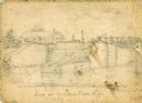
| Date: | 1856 |
|---|---|
| Description: | An original illustration of the lock at Rexford Flats. |

| Date: | 1855 |
|---|---|
| Description: | Fox-Wisconsin portage and canal map, when the canal was not yet built. From a map in the office of the city clerk at Portage. "The old trail, the location ... |

| Date: | 1853 |
|---|---|
| Description: | Wisconsin counties by color and shows railroads, common roads, canals, the state capital, county towns, townships, villages, and post offices, |

| Date: | 1854 |
|---|---|
| Description: | Map of the whole state Wisconsin includes an inset of the vicinity of Milwaukee, which shows the boundaries for Lisbon, Menomonee, Pewaukee, Brookfield, Wa... |

| Date: | 1857 |
|---|---|
| Description: | This detailed map was drawn nearly a decade after Wisconsin entered statehood. It depicts the entire state, northern Illinois and part of the upper peninsu... |
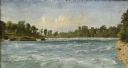
| Date: | 1856 |
|---|---|
| Description: | "....The third view was twelve miles farther up the river [from De Pere], at Rapid Croche, on the border of the present Brown and Outagamie counties. It is... |

| Date: | 1856 |
|---|---|
| Description: | ". . . The upper Grand Chute was the last of the 'improvements' paintings signed by Brookes and Stevenson. Yet there were two more vital links in the Fox R... |

| Date: | 1854 |
|---|---|
| Description: | Brightly-colored map exhaustively marks the townships, County Towns and villages of Wisconsin. It also shows rivers, canals, railroads, and plank roads. Ea... |

| Date: | 1853 |
|---|---|
| Description: | Engraved image of a boat being towed through a canal at Little Falls by a team of horses. A small town is in the background. |

| Date: | 1855 |
|---|---|
| Description: | This map shows landownership, lot and block numbers, streets, a canal, bridges, Fort Winnebago, the Wisconsin River, and the Fox River. Relief is shown by ... |

| Date: | 1851 |
|---|---|
| Description: | This map shows townships, villages, Indian villages, railroads, roads, mills, prairies, swamps, and canals. An inset map shows a plat of the copper distric... |

| Date: | 1857 |
|---|---|
| Description: | This map shows lot and block numbers, streets, railroad depots, locks, bridges, dams, canals, U.S. light house, college grounds, a steam boat landing, and ... |

| Date: | 1857 |
|---|---|
| Description: | This map shows the railroad routes of the Milwaukee & Horicon Railroad, common roads, counties, canals, townships, cities, county towns, villages, post off... |

| Date: | 1850 |
|---|---|
| Description: | This map shows the location of planned blocks and lot numbers, street names, and docks along the Fox River and canal. |
If you didn't find the material you searched for, our Library Reference Staff can help.
Call our reference desk at 608-264-6535 or email us at:
