 Filter: Categories of Wisconsin Historical Images
Filter: Subject of Canals
Filter: Subject of water
Filter: Categories of Wisconsin Historical Images
Filter: Subject of Canals
Filter: Subject of water

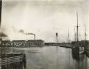
| Date: | 1875 |
|---|---|
| Description: | The harbor piers and the entrance to the Sturgeon Bay ship canal. Men are standing on the shoreline. |

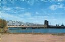
| Date: | 1915 |
|---|---|
| Description: | View of the Sturgeon Bay ship canal. Caption reads: "Sturgeon Bay Ship Canal." |

| Date: | 1913 |
|---|---|
| Description: | View of the canal. Caption reads: "The Canal, Stugeon[sic] Bay, Wis." |
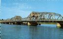
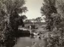
| Date: | |
|---|---|
| Description: | View of the bridge spanning the Sturgeon Bay canal. |
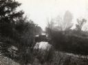
| Date: | |
|---|---|
| Description: | View from the shoreline of a bridge spanning the Sturgeon Bay canal. |

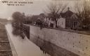
| Date: | 1870 |
|---|---|
| Description: | The corner of unpaved Main Street and Tayco Street looking south towards Doty Island. The slanting timbers controlled the primitive draw bridge across the ... |

| Date: | |
|---|---|
| Description: | Plat map of the east central part of the city. |
| Date: | 1935 |
|---|---|
| Description: | Elevated view of the Indian Agency House near the site of Fort Winnebago. View of Portage Canal in foreground. The canal was dug in 1849 as part of the Fox... |
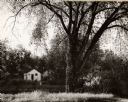
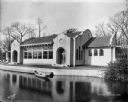
| Date: | 1962 |
|---|---|
| Description: | A view of a house beside the canal, from the south side. |

| Date: | 1855 |
|---|---|
| Description: | Fox-Wisconsin portage and canal map, when the canal was not yet built. From a map in the office of the city clerk at Portage. "The old trail, the location ... |
| Date: | 1910 |
|---|---|
| Description: | The Portage Canal at the Wisconsin River, showing the upper lock. Caption reads: "Upper Lock and Wisconsin River Portage Wis. No. 10". A group of people ar... |
| Date: | 1935 |
|---|---|
| Description: | A view of the Portage Canal and lock. The Indian Agency House in the center background. The canal was dug in 1849 as part of the Fox-Wisconsin waterway pro... |

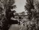
| Date: | 1915 |
|---|---|
| Description: | The Portage canal looking east from the Canal Bridge. Boats are lines up along the shoreline on the left near a long building. |
| Date: | 1935 |
|---|---|
| Description: | A view of the Portage Canal. In the immediate foreground is the Fox River, then the lower locks and the canal itself. The Indian Agency House may be seen t... |

| Date: | 1945 |
|---|---|
| Description: | An aerial view of the Portage Canal, Fox and Wisconsin Rivers. |
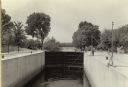
| Date: | 1935 |
|---|---|
| Description: | A view of the canal locks of the Portage Canal. Men are standing at the edge of the locks on the right. |
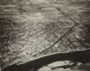
| Date: | 1945 |
|---|---|
| Description: | An elevated view of Portage and it's vicinity. |
| Date: | 1910 |
|---|---|
| Description: | Chicago River near International Harvester's McCormick Works (factory). A sailboat, water tower, railroad cars and many industrial buildings line the shore... |
| Date: | 11 01 1916 |
|---|---|
| Description: | Pavilion at Kosciusko Park lagoon at W. Lincoln Avenue and S. 7th Street. A rowboat is floating in the lagoon. |
If you didn't find the material you searched for, our Library Reference Staff can help.
Call our reference desk at 608-264-6535 or email us at:
