 Filter: Categories of Wisconsin Historical Images
Filter: Subject of Canals
Filter: Subject of steamboats
Filter: Categories of Wisconsin Historical Images
Filter: Subject of Canals
Filter: Subject of steamboats
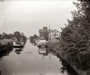
| Date: | 1885 |
|---|---|
| Description: | Steamboats docked in the Portage Canal, which was hand dug beginning in 1849 and completed in 1851. There are industrial buildings on either side of the ca... |
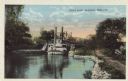
| Date: | |
|---|---|
| Description: | Colorized postcard of a steamboat passing through the canal lock along the Fox River. Caption reads: "Canal Lock, Appleton, Wis." |

| Date: | 1831 |
|---|---|
| Description: | Map of the city of Louisville, Kentucky on the Ohio River showing streets and numbered lots. The Ohio River, Corn Island, and the Louisville and Portland C... |
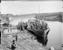
| Date: | 1918 |
|---|---|
| Description: | View looking down towards shoreline of troops on board a paddle boat on a canal. The boat flies an American flag. Other people stand on the shoreline and o... |
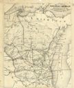
| Date: | 1878 |
|---|---|
| Description: | This map shows the advantages of the Sturgeon Bay and Lake Michigan Ship Canal, railroads, steamship lines across Lake Michigan, and Wisconsin township gri... |

| Date: | 1874 |
|---|---|
| Description: | Birds-eye view of Appleton Wisconsin. In the foreground are people fishing, strolling, and looking over the canal towards the Fox River. Streets and buildi... |
If you didn't find the material you searched for, our Library Reference Staff can help.
Call our reference desk at 608-264-6535 or email us at: