 Filter: Categories of Wisconsin Historical Images
Filter: Subject of Canals
Filter: Subject of service industries
Filter: Categories of Wisconsin Historical Images
Filter: Subject of Canals
Filter: Subject of service industries

| Date: | 1853 |
|---|---|
| Description: | Wisconsin counties by color and shows railroads, common roads, canals, the state capital, county towns, townships, villages, and post offices, |

| Date: | 1854 |
|---|---|
| Description: | Map of the whole state Wisconsin includes an inset of the vicinity of Milwaukee, which shows the boundaries for Lisbon, Menomonee, Pewaukee, Brookfield, Wa... |

| Date: | 1873 |
|---|---|
| Description: | Engraved image of a lock and dam at Sault St. Marie. Two men are operating the sluice as ships are waiting on the opposite side of the lock. Another man is... |
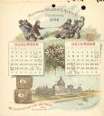
| Date: | 1892 |
|---|---|
| Description: | Sixth page of calendar for November and December, 1892. Features two illustrations: the top one of a group of boys in a tug of war using twine from a roll ... |

| Date: | 1966 |
|---|---|
| Description: | A colored map depiction of Door County, Wisconsin, with pictorial highlights, titled: "Door County — Wisconsin's Air Conditioned Peninsula Playground." |

| Date: | 1887 |
|---|---|
| Description: | This map shows sewers, manholes, streets, canals, rivers, and Lake Michigan. An explanation of sewer types is included. |

| Date: | 1891 |
|---|---|
| Description: | This blueprint manuscript map shows land owned by Kaukauna Water Power Co., Green Bay & Mississippi Canal Co., A.W. Patten, N.M. Edwards, and M.J. Meade. P... |

| Date: | 1857 |
|---|---|
| Description: | This map shows the railroad routes of the Milwaukee & Horicon Railroad, common roads, counties, canals, townships, cities, county towns, villages, post off... |
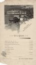
| Date: | 1893 |
|---|---|
| Description: | One-page tea room menu from the Woman's Building at the World's Columbian Exposition. At the top is an illustration of a gondolier steering a couple in a c... |

| Date: | 1950 |
|---|---|
| Description: | Subject: "TD-24 — Pipe Lines." Where Taken: "SW." Information with photograph reads: "TD-24 superior pipe boom owned by H.C. Price Company, Bartlesville, O... |
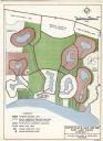
| Date: | 03 28 1964 |
|---|---|
| Description: | A master plan and land use map for East Lake Wales in Polk County, Florida showing where industrial sites, a shopping and civic center, golf course, marina... |
If you didn't find the material you searched for, our Library Reference Staff can help.
Call our reference desk at 608-264-6535 or email us at:

