 Filter: Categories of Wisconsin Historical Images
Filter: Subject of Canals
Filter: Subject of parks
Filter: Categories of Wisconsin Historical Images
Filter: Subject of Canals
Filter: Subject of parks

| Date: | |
|---|---|
| Description: | Plat map of the east central part of the city. |
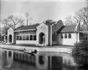
| Date: | 11 01 1916 |
|---|---|
| Description: | Pavilion at Kosciusko Park lagoon at W. Lincoln Avenue and S. 7th Street. A rowboat is floating in the lagoon. |

| Date: | 1878 |
|---|---|
| Description: | This map shows block numbers, wards, roads, railroads, parks, and selected buildings and includes a "Milwaukee city street guide" as well as a guide to pub... |

| Date: | 1939 |
|---|---|
| Description: | This nine-part map from the U.S. Bureau of Public Roads identifies federal and state highways in Wisconsin by pavement type. County, forest, park, and publ... |

| Date: | 1944 |
|---|---|
| Description: | This nine-part map from the U.S. Bureau of Public Roads identifies federal and state highways in Wisconsin by pavement type. County, forest, park, and publ... |

| Date: | 1936 |
|---|---|
| Description: | Street map of the City of Milwaukee and surrounding suburbs indicating various mass transit lines. There is an index to Milwaukee streets at the right of t... |

| Date: | 1910 |
|---|---|
| Description: | This ink on paper blue line print base map consists of eight separate pieces and shows city limits, The Milwaukee Electric Railroad & Light Company lines, ... |

| Date: | 2000 |
|---|---|
| Description: | This map shows the industrial area along the Menominee River and canals. Industrial buildings are shown in orange and labeled in red. Other areas are shown... |
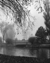
| Date: | 09 1964 |
|---|---|
| Description: | View across water towards two men standing on a stone bridge, in the early morning fog in September. The bridge is spanning one of the canals. Another man ... |
If you didn't find the material you searched for, our Library Reference Staff can help.
Call our reference desk at 608-264-6535 or email us at: