 Filter: Categories of Wisconsin Historical Images
Filter: Subject of Canals
Filter: Subject of land use, rural
Filter: Categories of Wisconsin Historical Images
Filter: Subject of Canals
Filter: Subject of land use, rural
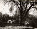
| Date: | 1962 |
|---|---|
| Description: | A view of a house beside the canal, from the south side. |
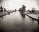
| Date: | 1900 |
|---|---|
| Description: | View down Portage Canal, with trees and open land on either side. |

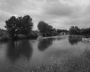
| Date: | 08 03 1962 |
|---|---|
| Description: | Elevated view of the Guard Lock on the Fox River Canal, looking east from the Highway 55 bridge. |
| Date: | 08 04 1962 |
|---|---|
| Description: | A boat travels up the Fox River. In the background are a canal and locks and factory smokestacks. |
| Date: | 1967 |
|---|---|
| Description: | Canal in a hamlet near Phat Diem, described by photographer David Schoenbrun as part of an extensive system of irrigation. On a path along the canal a man ... |

| Date: | 1840 |
|---|---|
| Description: | This map shows a line of proposed construction for defending the north side of the canal against inundation from the Wisconsin River and location of Fort W... |
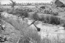
| Date: | 1961 |
|---|---|
| Description: | South Vietnamese soldiers from the Sea Swallow Army wading along a canal on patrol near the village of Binh Hung. Grass buildings are in the background nea... |

| Date: | 1790 |
|---|---|
| Description: | This map of the north eastern states shows roads, rivers, lakes, waterfalls, mountains, cities, forts, mills, the Oneida Reservation, and "New York Donatio... |

| Date: | 1793 |
|---|---|
| Description: | Detailed topographical map of the Ohio River between Clarkville and Louisville. It shows plots of farmland, forest, islands, garden plots, houses, Fort Fe... |
If you didn't find the material you searched for, our Library Reference Staff can help.
Call our reference desk at 608-264-6535 or email us at: