 Filter: Categories of Wisconsin Historical Images
Filter: Subject of Canals
Filter: Subject of harbors
Filter: Categories of Wisconsin Historical Images
Filter: Subject of Canals
Filter: Subject of harbors

| Date: | 1875 |
|---|---|
| Description: | The harbor piers and the entrance to the Sturgeon Bay ship canal. Men are standing on the shoreline. |
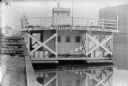
| Date: | |
|---|---|
| Description: | Elevated view of tugboat pulling a steamer caked in ice in a canal. Steam is rising from the water and an open drawbridge can be seen in the background. On... |

| Date: | 1951 |
|---|---|
| Description: | This map shows Ashland and Washburn harbors in shades of blue and yellow. Water depths shown by isolines and soundings, and relief is shown by contours. Th... |

| Date: | 06 25 1901 |
|---|---|
| Description: | This map shows beacons, buoys, docks, quarries, streets, and buildings. The map inset shows the Harbor of refuge at entrance to Sturgeon Bay and Lake Michi... |

| Date: | 01 06 1958 |
|---|---|
| Description: | View of the Ship Canal from the Coast Guard station. There are pieces of machinery on the right, and a line of trees on the left. There is snow on the grou... |

| Date: | 1907 |
|---|---|
| Description: | This map is a chart of Milwaukee Harbor that displays local streets, bridges, roads, railroads, public buildings, businesses, factories, dry docks, parks, ... |

| Date: | 1923 |
|---|---|
| Description: | This map includes an explanation that reads: "This chart shows the movement of oats on the Great Lakes, St. Lawrence River, and New York State Barge Canal ... |

| Date: | 1900 |
|---|---|
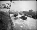
| Description: | View across water towards a float(?) erected in harbor alongside docks at McCormick Works. |
| Date: | 1900 |
|---|---|
| Description: | View along dock towards a boat with two decks (float?) anchored in harbor at McCormick Works. Painted on the back of the boat is a sign that reads: "McCorm... |

| Date: | 04 1926 |
|---|---|
| Description: | This blueprint mostly shows various numbers within the canal and bay. Lake Michigan and Harobor of Refuge are shown along the far right side. Near the harb... |

| Date: | 07 06 1931 |
|---|---|
| Description: | Text on front reads: "Where Green Bay and Sturgeon Bay Meet, Sturgeon Bay, Wis." Aerial view of Sturgeon Bay showing the only bridge in existence at the ti... |
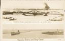
| Date: | 1907 |
|---|---|
| Description: | Postcard with two images. The top text reads: "Interstate Bridge, connecting Superior, Wis. and Duluth, Minn." The bottom text reads: "Superior Entry and S... |
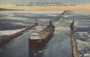
| Date: | 06 14 1947 |
|---|---|
| Description: | Text on front reads: "Opening of Navigation Season, First Giant Freighters Entering Ship Canal and Duluth-Superior Harbor." On reverse: "The navigation sea... |
If you didn't find the material you searched for, our Library Reference Staff can help.
Call our reference desk at 608-264-6535 or email us at: