 Filter: Categories of Wisconsin Historical Images
Filter: Subject of Canals
Filter: Subject of dwellings
Filter: Categories of Wisconsin Historical Images
Filter: Subject of Canals
Filter: Subject of dwellings

| Date: | 1892 |
|---|---|
| Description: | Bird's-eye map of Princeton, with an inset of the Residence of F.T. Yahr. Fox River loops to left of center, with one bridge; thirty-six businesses, reside... |
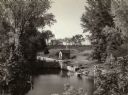
| Date: | 1935 |
|---|---|
| Description: | Elevated view of the Portage canal and lock, with the Indian Agency House in the center background. The canal was dug in 1849 as part of the Fox-Wisconsin ... |
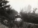
| Date: | 1962 |
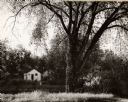
|---|---|
| Description: | A view of a house beside the canal, from the south side. |
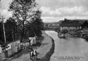
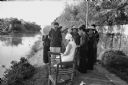
| Date: | 1910 |
|---|---|
| Description: | The Portage Canal at the Wisconsin River, showing the upper lock. Caption reads: "Upper Lock and Wisconsin River Portage Wis. No. 10". A group of people ar... |
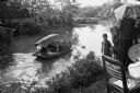
| Date: | 1935 |
|---|---|
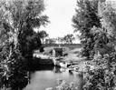
| Description: | A view of the Portage Canal and lock. The Indian Agency House in the center background. The canal was dug in 1849 as part of the Fox-Wisconsin waterway pro... |
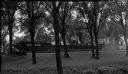
| Date: | 1935 |
|---|---|
| Description: | A view of the Portage Canal. In the immediate foreground is the Fox River, then the lower locks and the canal itself. The Indian Agency House may be seen t... |
| Date: | 1900 |
|---|---|
| Description: | Elevated view of a man with two mules on the left pulling a boat up the Chesapeake and Ohio Canal. A large wooden building is on the right bank in the behi... |
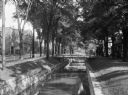
| Date: | |
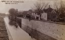
|---|---|
| Description: | View of a tree-lined waterway that runs through a residential area. The street and commercial buildings are on the left, and there are footbridges from the... |

| Date: | |
|---|---|
| Description: | Bird's-eye view of the north branch extension canal on the Susquehanna river, surrounded by smaller renderings of structures of interest around the town in... |
| Date: | |
|---|---|
| Description: | View of the side of a barge owned by the Pluswood company on the Fox River Canal. The boat is seen through the trees on the lawn of the Charles A. Grignon ... |
| Date: | 1967 |
|---|---|
| Description: | Villagers near Phat Diem gathered to watch American Dorothy Schoenbrun sketching near an irrigation canal. Mrs. Schoenbrun was accompanying her husband, jo... |
| Date: | 1967 |
|---|---|
| Description: | Person steering a sampan, loaded with what appears to be fiber, on an irrigation canal near the North Vietnamese city of Phat Diem. On the right is a group... |

| Date: | 1962 |
|---|---|
| Description: | A woman carrying a child wrapped in a cloth crosses a log footbridge over a canal in the countryside in Vietnam. A boy is standing in the background and th... |
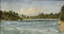
| Date: | 1856 |
|---|---|
| Description: | "....The third view was twelve miles farther up the river [from De Pere], at Rapid Croche, on the border of the present Brown and Outagamie counties. It is... |

| Date: | 1856 |
|---|---|
| Description: | ". . . The upper Grand Chute was the last of the 'improvements' paintings signed by Brookes and Stevenson. Yet there were two more vital links in the Fox R... |

| Date: | 1906 |
|---|---|
| Description: | Hand-colored postcard view of the Sturgeon Bay ship canal from the bay toward shore. A sailboat is on the left and a lighthouse is on shore on the right. C... |

| Date: | 1964 |
|---|---|
| Description: | Men and young children in a roofed enclosure outside a dwelling near the village of Binh Hung, South Vietnam. Several of the children are plugging their ea... |
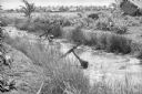
| Date: | 1961 |
|---|---|
| Description: | South Vietnamese soldiers from the Sea Swallow Army wading along a canal on patrol near the village of Binh Hung. Grass buildings are in the background nea... |

| Date: | 1964 |
|---|---|
| Description: | View looking over barbed wire towards a helicopter flying over the village of Binh Hung, a base for the fighting operations for the South Vietnamese. Two c... |

| Date: | 1793 |
|---|---|
| Description: | Detailed topographical map of the Ohio River between Clarkville and Louisville. It shows plots of farmland, forest, islands, garden plots, houses, Fort Fe... |
If you didn't find the material you searched for, our Library Reference Staff can help.
Call our reference desk at 608-264-6535 or email us at: