 Filter: Categories of Wisconsin Historical Images
Filter: Subject of Canals
Filter: Subject of dams
Filter: Categories of Wisconsin Historical Images
Filter: Subject of Canals
Filter: Subject of dams

| Date: | 1872 |
|---|---|
| Description: | Birds-eye drawing of Eau Claire depicts street names and street locations, houses, trees, bridges, piers, canals, railroads, and the Chippewa and Eau Clair... |
| Date: | 1856 |
|---|---|
| Description: | An original illustration of the lock at Rexford Flats. |

| Date: | 08 05 1962 |
|---|---|
| Description: | Exterior view of Riverside Paper Corporation mill. On the left is a road along a river, and on the right are railroad tracks along the mill. A sign in the ... |

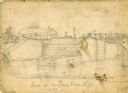
| Date: | 1856 |
|---|---|
| Description: | "....The third view was twelve miles farther up the river [from De Pere], at Rapid Croche, on the border of the present Brown and Outagamie counties. It is... |

| Date: | 1873 |
|---|---|
| Description: | Engraved image of a lock and dam at Sault St. Marie. Two men are operating the sluice as ships are waiting on the opposite side of the lock. Another man is... |

| Date: | 1828 |
|---|---|
| Description: | Map of the Louisville and Portland Canal on the Ohio River. The map shows Louisville, Shippingsport, Clarksville, Jeffersonville, Gravel Island, Corn Islan... |

| Date: | 1846 |
|---|---|
| Description: | This plat map, which features the very early spelling of Wisconsin as "Wiskonsin", was created sometime between 1846 and 1854 and shows a canal and dam on ... |
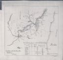
| Date: | 1897 |
|---|---|
| Description: | This map shows the distances along Fox River, as well as adjacent lakes and railroads, between Green Bay and the Wisconsin River. Lake Michigan is on the f... |

| Date: | |
|---|---|
| Description: | Elevated view of a canal, reservoir and dam on the Fox River. Two men are standing near a boathouse. Caption reads: "Canal Entrance and Dam, Kaukauna, Wis.... |
If you didn't find the material you searched for, our Library Reference Staff can help.
Call our reference desk at 608-264-6535 or email us at: