 Filter: Categories of Wisconsin Historical Images
Filter: Subject of Canals
Filter: Subject of commercial buildings
Filter: Categories of Wisconsin Historical Images
Filter: Subject of Canals
Filter: Subject of commercial buildings
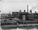
| Date: | 1900 |
|---|---|
| Description: | Elevated view across canal of the McCormick Reaper Works, rail yard, and surrounding buildings. After 1902, the factory became International Harvester's Mc... |

| Date: | 1870 |
|---|---|
| Description: | The corner of unpaved Main Street and Tayco Street looking south towards Doty Island. The slanting timbers controlled the primitive draw bridge across the ... |
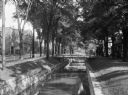
| Date: | 1962 |
|---|---|
| Description: | The Portage Canal between the Wisconsin and Fox Rivers, from the highway 51 crossing near the center of the city. |
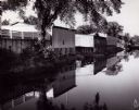
| Date: | |
|---|---|
| Description: | View of a tree-lined waterway that runs through a residential area. The street and commercial buildings are on the left, and there are footbridges from the... |
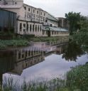
| Date: | 07 1966 |
|---|---|
| Description: | View across canal towards the back of the Portage Hosiery. Reeds and trees are along the edge of the canal. Red and pink colored liquid is floating on the ... |
If you didn't find the material you searched for, our Library Reference Staff can help.
Call our reference desk at 608-264-6535 or email us at:
