 Filter: Categories of Wisconsin Historical Images
Filter: Subject of Canals
Filter: Subject of canals
Filter: Categories of Wisconsin Historical Images
Filter: Subject of Canals
Filter: Subject of canals
| Date: | 1967 |
|---|---|
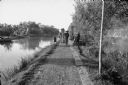
| Description: | Canal in a hamlet near Phat Diem, described by photographer David Schoenbrun as part of an extensive system of irrigation. On a path along the canal a man ... |
| Date: | 1967 |
|---|---|
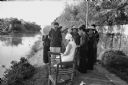
| Description: | Villagers near Phat Diem gathered to watch American Dorothy Schoenbrun sketching near an irrigation canal. Mrs. Schoenbrun was accompanying her husband, jo... |
| Date: | 1967 |
|---|---|
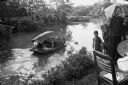
| Description: | Person steering a sampan, loaded with what appears to be fiber, on an irrigation canal near the North Vietnamese city of Phat Diem. On the right is a group... |
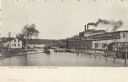
| Date: | |
|---|---|
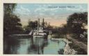
| Description: | Colorized postcard of a steamboat passing through the canal lock along the Fox River. Caption reads: "Canal Lock, Appleton, Wis." |
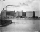
| Date: | |
|---|---|
| Description: | View of the Inter Lake Pulp Mill. Smoke is billowing out of the mill's smokestack. A boat is crossing the canal between two lakes. Caption reads: "Inter La... |
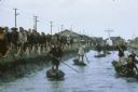
| Date: | 1962 |
|---|---|
| Description: | Canal in Binh Hung Vietnam with numerous small boats and a crowd of people walking alongside. In the background is a large cross and a number of large that... |

| Date: | 1962 |
|---|---|
| Description: | Three farmers remove large chunks of earth from the side of an irrigation canal in Vietnam to widen it. One man stands with a tool on the bank to dislodge ... |
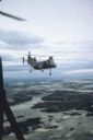
| Date: | 06 1962 |
|---|---|
| Description: | Aerial view of old U.S. Army model H-21 helicopter, assigned to help Vietnamese forces fight the Viet Cong in the mountain region of Vietnam. The patchwork... |

| Date: | 05 1962 |
|---|---|
| Description: | Vietnamese Rangers escort a newly captured prisoner suspected of being Viet Cong down a gravel road in the vicinity of Bac Lien, Vietnam. The prisoner has ... |

| Date: | 1962 |
|---|---|
| Description: | A woman carrying a child wrapped in a cloth crosses a log footbridge over a canal in the countryside in Vietnam. A boy is standing in the background and th... |

| Date: | 1878 |
|---|---|
| Description: | This map shows block numbers, wards, roads, railroads, parks, and selected buildings and includes a "Milwaukee city street guide" as well as a guide to pub... |

| Date: | 1891 |
|---|---|
| Description: | Color illustration of the grounds and buildings of the 1893 World's Fair or Columbian Exposition. |

| Date: | 1942 |
|---|---|
| Description: | This map shows the Wisconsin and Fox River routes in green, and the Milwaukee and Rock River Canal routes in red. Prairie du Chien, Fort Winnebago, Grand C... |

| Date: | 1900 |
|---|---|
| Description: | McCormick Reaper Works, as seen from across the west fork of the south branch of the Chicago River. There are stacks of lumber in the foreground, and railr... |

| Date: | 1900 |
|---|---|
| Description: | View of what appears to be the McCormick Reaper Works, with the west fork of the south branch of the Chicago River in the foreground. Smokestacks, railroad... |
| Date: | 1900 |
|---|---|
| Description: | View of factory buildings and smokestacks from across a river or industrial canal. The factory is probably the McCormick Reaper Works as seen from across t... |

| Date: | 1853 |
|---|---|
| Description: | Wisconsin counties by color and shows railroads, common roads, canals, the state capital, county towns, townships, villages, and post offices, |

| Date: | 1854 |
|---|---|
| Description: | Map of the whole state Wisconsin includes an inset of the vicinity of Milwaukee, which shows the boundaries for Lisbon, Menomonee, Pewaukee, Brookfield, Wa... |

| Date: | 1857 |
|---|---|
| Description: | This detailed map was drawn nearly a decade after Wisconsin entered statehood. It depicts the entire state, northern Illinois and part of the upper peninsu... |
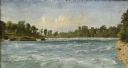
| Date: | 1856 |
|---|---|
| Description: | "....The third view was twelve miles farther up the river [from De Pere], at Rapid Croche, on the border of the present Brown and Outagamie counties. It is... |
If you didn't find the material you searched for, our Library Reference Staff can help.
Call our reference desk at 608-264-6535 or email us at: