 Filter: Categories of Wisconsin Historical Images
Filter: Subject of Canals
Filter: Subject of arts
Filter: Categories of Wisconsin Historical Images
Filter: Subject of Canals
Filter: Subject of arts
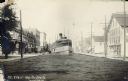
| Date: | 11 17 1909 |
|---|---|
| Description: | A riverboat travels down a narrow canal. Storefronts, sidewalks and telephone poles line either side of the canal. Caption reads: "St. Clair Up-to-Date." ... |
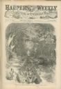
| Date: | 08 02 1862 |
|---|---|
| Description: | Engraved view of several men in a long trench digging Grant's canal on the Mississippi River opposite Vicksburg. |
| Date: | 1903 |
|---|---|
| Description: | Lock and dam system on a canal along the Mississippi River. |

| Date: | 1893 |
|---|---|
| Description: | View of the canal area of the Columbian Exposition grounds looking north from near the front of the Machinery building (at left). The South canal is in the... |
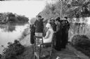
| Date: | 1967 |
|---|---|
| Description: | Villagers near Phat Diem gathered to watch American Dorothy Schoenbrun sketching near an irrigation canal. Mrs. Schoenbrun was accompanying her husband, jo... |

| Date: | 1873 |
|---|---|
| Description: | Engraved image of a lock and dam at Sault St. Marie. Two men are operating the sluice as ships are waiting on the opposite side of the lock. Another man is... |
| Date: | 1825 |
|---|---|
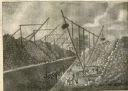
| Description: | Engraved view of several wooden cranes extracting large stones from a cut during the construction of the Erie Canal. The rig in the foreground is horse-dri... |
| Date: | 1825 |
|---|---|
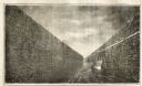
| Description: | Engraved view of boats being towed by horses through the Erie Canal at Lockport Erie Canal at Lockport. The horses can be seen on a high towpath at right. ... |

| Date: | 1831 |
|---|---|
| Description: | Map of the city of Louisville, Kentucky on the Ohio River showing streets and numbered lots. The Ohio River, Corn Island, and the Louisville and Portland C... |

| Date: | 1828 |
|---|---|
| Description: | Map of the Louisville and Portland Canal on the Ohio River. The map shows Louisville, Shippingsport, Clarksville, Jeffersonville, Gravel Island, Corn Islan... |

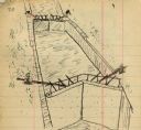
| Date: | 1828 |
|---|---|
| Description: | Increase Lapham's drawing and description of an earth borer for his handwritten manuscript, Notes and Accounts of Canals, Particularly the Ohio Canal Ne... |
| Date: | 08 1892 |
|---|---|
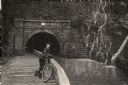
| Description: | Engraving, probably after a photograph, showing Frank Lenz posing with his safety bicycle near the stone arch entrance of a canal tunnel cut through a moun... |

| Date: | 03 24 1950 |
|---|---|
| Description: | Front cover of a farewell dinner menu from the Italian Line ship Saturnia, with two Commedia dell' Arte characters: Pantalone, a black masked figure... |

| Date: | 1836 |
|---|---|
| Description: | This map shows lot and block numbers, streets, a proposed canal basin, Fort Winnebago, and the Wisconsin and Fox Rivers. Relief is shown by hachures and no... |

| Date: | 1790 |
|---|---|
| Description: | This map of the north eastern states shows roads, rivers, lakes, waterfalls, mountains, cities, forts, mills, the Oneida Reservation, and "New York Donatio... |

| Date: | 1793 |
|---|---|
| Description: | Detailed topographical map of the Ohio River between Clarkville and Louisville. It shows plots of farmland, forest, islands, garden plots, houses, Fort Fe... |
If you didn't find the material you searched for, our Library Reference Staff can help.
Call our reference desk at 608-264-6535 or email us at: