 Filter: Categories of Wisconsin Historical Images
Filter: Subject of Canals
Filter: County of Winnebago
Filter: Categories of Wisconsin Historical Images
Filter: Subject of Canals
Filter: County of Winnebago
| Date: | 09 14 1963 |
|---|---|
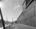
| Description: | The Marathon Paper Corporation plant along the historic Fox River canal. |
| Date: | 09 29 1963 |
|---|---|
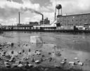
| Description: | The Menasha Woodenware plant and water tower on Doty Island from across the Fox River canal, with a small railroad dolly in the foreground. |

| Date: | 1870 |
|---|---|
| Description: | The corner of unpaved Main Street and Tayco Street looking south towards Doty Island. The slanting timbers controlled the primitive draw bridge across the ... |
| Date: | 09 30 1963 |
|---|---|
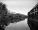
| Description: | View of a canal running between the Neenah Paper Company and the J.W. Hewitt Machine Company. |

| Date: | 09 29 1963 |
|---|---|
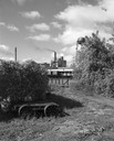
| Description: | View across water of a railroad bridge along the side of a strip of industrial buildings. Railroad cars are stopped in front of the buildings. |

| Date: | 1856 |
|---|---|
| Description: | ". . . The upper Grand Chute was the last of the 'improvements' paintings signed by Brookes and Stevenson. Yet there were two more vital links in the Fox R... |

| Date: | 1881 |
|---|---|
| Description: | Ink, watercolor, and pencil on paper. Top of the map reads: "NORTHERN OUTLET MENASHA MEANDER LINES Scale 132ft 1 INCH Var S.E. Survey Completed Spet. 23 18... |

| Date: | 1876 |
|---|---|
| Description: | This map is of the towns of Neenah and Menasha and shows existing and proposed canals. Water depths shown by soundings. Little Butte des Morts Lake, Doty I... |

| Date: | 1846 |
|---|---|
| Description: | This plat map, which features the very early spelling of Wisconsin as "Wiskonsin", was created sometime between 1846 and 1854 and shows a canal and dam on ... |

| Date: | 12 1886 |
|---|---|
| Description: | This map is ink and pen on tracing cloth and shows land ownership by name, canals, local streets, section lines, and original low water lines in blue. The ... |

| Date: | 1840 |
|---|---|
| Description: | This map shows a line of proposed construction for defending the north side of the canal against inundation from the Wisconsin River and location of Fort W... |
| Date: | 1963 |
|---|---|
| Description: | A diagonal view down the canal of the Menasha Woodenware Company. Along the opposite side of the canal are boxcars on an elevated railroad track over the w... |

| Date: | 1857 |
|---|---|
| Description: | This map shows lot and block numbers, streets, railroad depots, locks, bridges, dams, canals, U.S. light house, college grounds, a steam boat landing, and ... |

| Date: | 1886 |
|---|---|
| Description: | View across water towards the George Whiting Paper Mill on the Lawson Canal. |
If you didn't find the material you searched for, our Library Reference Staff can help.
Call our reference desk at 608-264-6535 or email us at: