 Filter: Categories of Wisconsin Historical Images
Filter: Subject of Canals
Filter: County of Winnebago
Filter: Community of Neenah
Filter: Categories of Wisconsin Historical Images
Filter: Subject of Canals
Filter: County of Winnebago
Filter: Community of Neenah
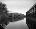
| Date: | 09 30 1963 |
|---|---|
| Description: | View of a canal running between the Neenah Paper Company and the J.W. Hewitt Machine Company. |

| Date: | 1876 |
|---|---|
| Description: | This map is of the towns of Neenah and Menasha and shows existing and proposed canals. Water depths shown by soundings. Little Butte des Morts Lake, Doty I... |

| Date: | 1846 |
|---|---|
| Description: | This plat map, which features the very early spelling of Wisconsin as "Wiskonsin", was created sometime between 1846 and 1854 and shows a canal and dam on ... |

| Date: | 1840 |
|---|---|
| Description: | This map shows a line of proposed construction for defending the north side of the canal against inundation from the Wisconsin River and location of Fort W... |
If you didn't find the material you searched for, our Library Reference Staff can help.
Call our reference desk at 608-264-6535 or email us at: