 Filter: Categories of Wisconsin Historical Images
Filter: Subject of Canals
Filter: County of Columbia
Filter: Categories of Wisconsin Historical Images
Filter: Subject of Canals
Filter: County of Columbia
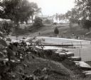
| Date: | 1929 |
|---|---|
| Description: | A view of the canal locks on the Fox River. The Indian Agency House is in the background on a hill. |
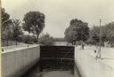
| Date: | 1935 |
|---|---|
| Description: | A view of the canal locks of the Portage Canal. Men are standing at the edge of the locks on the right. |
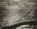
| Date: | 1945 |
|---|---|
| Description: | An elevated view of Portage and it's vicinity. |

| Date: | 1800 |
|---|---|
| Description: | This map shows the land claim owned by the Portage Canal Company and includes an index of landownership and landmarks. The Wisconsin and Portage River, the... |

| Date: | 1836 |
|---|---|
| Description: | This map shows lot and block numbers, streets, a proposed canal basin, Fort Winnebago, and the Wisconsin and Fox Rivers. Relief is shown by hachures and no... |

| Date: | 1855 |
|---|---|
| Description: | This map shows landownership, lot and block numbers, streets, a canal, bridges, Fort Winnebago, the Wisconsin River, and the Fox River. Relief is shown by ... |
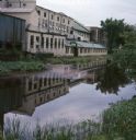
| Date: | 07 1966 |
|---|---|
| Description: | View across canal towards the back of the Portage Hosiery. Reeds and trees are along the edge of the canal. Red and pink colored liquid is floating on the ... |
If you didn't find the material you searched for, our Library Reference Staff can help.
Call our reference desk at 608-264-6535 or email us at: