 Filter: Categories of Wisconsin Historical Images
Filter: Subject of Camps
Filter: Year of 1900-1999
Filter: Categories of Wisconsin Historical Images
Filter: Subject of Camps
Filter: Year of 1900-1999
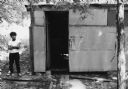
| Date: | 1969 |
|---|---|
| Description: | A boy wearing a white short-sleeved t-shirt and dark pants is barefoot and standing to the left of a communal shower hut for migrant farm workers in a Waut... |
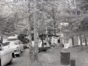
| Date: | 1960 |
|---|---|
| Description: | A camping site in Northern Wisconsin. Two women prepare food under a tent's canopy. The site includes: two parked cars, a clothesline holding wet towels, t... |
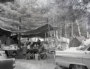
| Date: | 1960 |
|---|---|
| Description: | A campsite at Hiawatha National Forest. Men and women sits at a picnic table, while children sit by the campfire. |

| Date: | 1936 |
|---|---|
| Description: | This 1936 Wisconsin Conservation Dept. map shows the locations of state forestry Civilian Conservation Corps (CCC) camps, closed state forestry CCC camps, ... |

| Date: | 1937 |
|---|---|
| Description: | This Wisconsin Conservation Department map shows the locations of state forests, national forests, county forests, state nurseries, Indian reservations, st... |

| Date: | 1930 |
|---|---|
| Description: | Hand-colored image of two swimmers sitting on a pier with their legs in the water at a camp in West Point sponsored by Neighborhood House. Several other sw... |
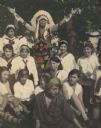
| Date: | 1930 |
|---|---|
| Description: | Hand-colored group portrait of Camp Fire girls and a man dressed in Ojibwa-style floral embroidered/beaded clothing and a Plains Indian feathered headdress... |

| Date: | 1926 |
|---|---|
| Description: | This Wisconsin Conservation Commission map from the 1920s shows roads, railroads, campsites, lookout towers, and privately owned lands in Northern Forest S... |
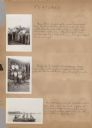
| Date: | 1942 |
|---|---|
| Description: | Page from a scrapbook kept by Neighborhood House, with highlights of the boys summer camp at Camp America Williams: "backwards" day, with a line of boys dr... |

| Date: | 1916 |
|---|---|
| Description: | This Wisconsin Conservation Commission map from 1916 shows Peninsula State Park in the Town of Gibraltar, Door County, Wisconsin. Depicted are open and pla... |

| Date: | 1916 |
|---|---|
| Description: | This version of a 1916 Wisconsin Conservation Commission map shows Peninsula State Park in the Town of Gibraltar, Door County, Wisconsin. Depicted are open... |
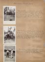
| Date: | 07 1942 |
|---|---|
| Description: | Page from a scrapbook kept by Neighborhood House, with images from an archery tournament at a summer camp for boys at Camp America Williams: a group of fin... |
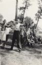
| Date: | 07 1942 |
|---|---|
| Description: | Image from a scrapbook kept by Neighborhood House, with Pat McCann, the last shooter in an archery tournament held at a boys summer camp, drawing the bow a... |
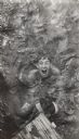
| Date: | 07 1942 |
|---|---|
| Description: | Image from a scrapbook kept by Neighborhood House of a boys summer camp, with an image of Skip Sul?(obscured letters) participating in a game involving tak... |

| Date: | 1902 |
|---|---|
| Description: | This 1902 map of the eastern portion of Sawyer County, Wisconsin, shows the township and range system, sections, roads, farm houses, camps, school houses, ... |

| Date: | 1926 |
|---|---|
| Description: | This 1926 map depicts resorts and camps, lakes and streams, railroads, and roads in portions of Vilas, Iron, Oneida, Price, and Lincoln counties in Wiscons... |

| Date: | 1967 |
|---|---|
| Description: | This tourist brochure for Bayfield County, Wisconsin, from 1967 includes a map of the county showing towns, cities and villages, highways and roads, railro... |

| Date: | 1929 |
|---|---|
| Description: | Group of boys standing in line, holding empty plates to be filled by a cook, wearing a chef's hat, who is standing behind a half-door with a pan in one han... |

| Date: | 1929 |
|---|---|
| Description: | Group of boys getting ready for bed in a corner of The Roost in Piper's Woods (a 10 acre woods located a mile and a half past Forest Hill cemetery on the S... |

| Date: | 1900 |
|---|---|
| Description: | Shows lands belonging to Wisconsin Timber and Land Co., towns, post offices, saw mills, creameries, camps, churches, schools, farm houses, town halls, rail... |
If you didn't find the material you searched for, our Library Reference Staff can help.
Call our reference desk at 608-264-6535 or email us at: