 Filter: Categories of Wisconsin Historical Images
Filter: Subject of Camps
Filter: County of Sawyer
Filter: Categories of Wisconsin Historical Images
Filter: Subject of Camps
Filter: County of Sawyer

| Date: | 1902 |
|---|---|
| Description: | This 1902 map of the eastern portion of Sawyer County, Wisconsin, shows the township and range system, sections, roads, farm houses, camps, school houses, ... |
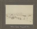
| Date: | 1910 |
|---|---|
| Description: | View of multiple structures in winter, with bare trees and stumps among them. A wigwam/wiigiwaam is visible in the distance, and a tipi is closer. A log st... |
If you didn't find the material you searched for, our Library Reference Staff can help.
Call our reference desk at 608-264-6535 or email us at: