 Filter: Categories of Wisconsin Historical Images
Filter: Subject of Camping
Filter: Year of 1900-1999
Filter: Categories of Wisconsin Historical Images
Filter: Subject of Camping
Filter: Year of 1900-1999

| Date: | 1991 |
|---|---|
| Description: | This map shows public access, fish crib locations, resorts, and other local businesses as well as advertisements for local attractions and a resort index. ... |

| Date: | 1987 |
|---|---|
| Description: | This map shows county forests, state, federal, and interstate highways. County forests lands are shown in light green. The front of the map includes images... |

| Date: | 1973 |
|---|---|
| Description: | A man and woman are eating in front of a campfire. A red 100 pickup is parked on the left. In the background is a tent. The campsite is set up on the shore... |

| Date: | 1921 |
|---|---|
| Description: | This map shows in red the NorthWestern Railway Line routes running from Chicago, Illinois to northern Wisconsin and Michigan. The map includes cities and t... |

| Date: | 1929 |
|---|---|
| Description: | This map of the entire state includes portions of Illinois, Iowa, Michigan, and Minnesota. The map shows U.S., state, and county highways, roads, campsites... |

| Date: | 1922 |
|---|---|
| Description: | This map shows in red the NorthWestern Railway Line routes running from Chicago, Illinois to northern Wisconsin. The map includes cities and towns, lakes, ... |

| Date: | 1925 |
|---|---|
| Description: | The map shows the entire state with portions of Illinois, Iowa, Minnesota, and Michigan. The map shows concrete, gravel, all weather earth, clay, and sand ... |

| Date: | 1905 |
|---|---|
| Description: | Campers on Picnic Point. Tents are set up along the shore, under the trees. A few campers are in front of their tents. A canoe is barely visible on the rig... |

| Date: | 1914 |
|---|---|
| Description: | Jack sitting outdoors on a folding camp chair, drawing on a pad of paper at camp. |
| Date: | 1916 |
|---|---|
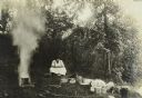
| Description: | Joe Paris making drop cakes for lunch at The Gang's camp. |
| Date: | 08 1916 |
|---|---|
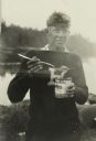
| Description: | Russell Greene enjoying his dinner, which he is spooning from a can. He is standing by the river wearing a letter sweater. |
| Date: | 08 1916 |
|---|---|
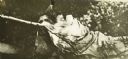
| Description: | Jack is roped into his bedroll while asleep by prankster Doc Copeland. |

| Date: | 1911 |
|---|---|
| Description: | L-R: Doc Copeland, Carl, and Bill Marr playing poker in the tent. |

| Date: | 1966 |
|---|---|
| Description: | This colored road map shows automobile roads in Wisconsin as well as portions of nearby states. Information on the quality and type of any road shown (inte... |

| Date: | 1966 |
|---|---|
| Description: | This colored road map shows automobile roads in Wisconsin as well as portions of nearby states. A map key indicates relative sizes of cities and towns. On ... |

| Date: | 1970 |
|---|---|
| Description: | This colored map displays a brief description of tourist attractions in the state, as well as a grid of state parks and recreational facilities. There is a... |

| Date: | 1966 |
|---|---|
| Description: | This colored road map shows automobile roads in Wisconsin as well as portions of nearby states. Information on the quality and type of any road shown (inte... |

| Date: | 1972 |
|---|---|
| Description: | This colored map displays Wisconsin and bordering areas of Iowa, Minnesota, and Michigan. There is color-coding on the map to indicate National Forests, an... |

| Date: | 1970 |
|---|---|
| Description: | This colored map displays detailed maps of Green Bay, Appleton, Racine, Milwaukee, Kenosha, and Duluth-Superior. At the top right is a map location list of... |

| Date: | 1971 |
|---|---|
| Description: | This colored map displays Wisconsin and bordering areas of Iowa, Minnesota, and Michigan. There is color-coding on the map to indicate National Forests, an... |
If you didn't find the material you searched for, our Library Reference Staff can help.
Call our reference desk at 608-264-6535 or email us at: