 Filter: Categories of Wisconsin Historical Images
Filter: Subject of Camping
Filter: Subject of botany
Filter: Categories of Wisconsin Historical Images
Filter: Subject of Camping
Filter: Subject of botany

| Date: | 1910 |
|---|---|
| Description: | View along shoreline towards White City, a group of white camping tents, pitched along the Chippewa River. People are in boats near the shoreline. Caption ... |
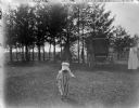
| Date: | |
|---|---|
| Description: | View towards a small child walking in the foreground, wearing a bonnet and striped overalls. In the background on the right near a wagon is a woman in a wh... |
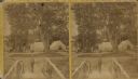
| Date: | 1890 |
|---|---|
| Description: | Stereograph view from footbridge with rustic railings of a small boy wearing a large hat standing at the end of the footbridge. A group of adults and anoth... |

| Date: | |
|---|---|
| Description: | View of two tents in a clearing surrounded by trees. A man and his dog are standing in the center. |

| Date: | 1950 |
|---|---|
| Description: | Sue Ann Hackett kneeling and holding a tin cup on an outdoor camping trip. There is a tarp in the foreground with dishes and food containers. Birch trees a... |

| Date: | 1975 |
|---|---|
| Description: | This map shows boundaries, roads, national forest land, bogs and wetlands, lakes, campgrounds, and boat landings. |

| Date: | |
|---|---|
| Description: | Three-quarter view from front of passenger side of Scout with camper top parked outdoors. A man is standing looking at rocks set on the hood. |

| Date: | |
|---|---|
| Description: | Three-quarter view from front of passenger side of Scout with camper top parked outdoors. A man is standing looking at rocks set on the hood. |

| Date: | 1894 |
|---|---|
| Description: | Seven members of the canoe association are posed around an eighth member, who is lying face down on a padded cot, covered with ferns. Ferns have been strat... |

| Date: | 1980 |
|---|---|
| Description: | This map shows the locations of 42 businesses, roads, points of interest, recreation sites, camping, the North Country Trail and parking, and boundaries of... |

| Date: | 2000 |
|---|---|
| Description: | This map shows national parks, county and state forests, Indian reservations, municipal land, private land, docks, boat access, camping, and points of inte... |
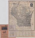
| Date: | 1924 |
|---|---|
| Description: | This map shows road surfacings, camp sites, state parks, proposed state parks, rivers, lakes, towns, and county boundaries. Includes a legend of road surfa... |

| Date: | 1926 |
|---|---|
| Description: | This map shows road surfacings, camp sites, state parks, proposed state parks, rivers, lakes, county boundaries, and cities. Includes portions of Minnesota... |

| Date: | 1966 |
|---|---|
| Description: | This map includes a red overprint on base map and shows the supervisors and district numbers of St. Croix County. Includes diagrams of civil towns, townsh... |

| Date: | 1987 |
|---|---|
| Description: | This map shows county forests, state, federal, and interstate highways. County forests lands are shown in light green. The front of the map includes images... |

| Date: | |
|---|---|
| Description: | Informal portrait of Frederick Jackson Turner standing in the woods on a camping trip. |

| Date: | 1973 |
|---|---|
| Description: | A man and woman are eating in front of a campfire. A red 100 pickup is parked on the left. In the background is a tent. The campsite is set up on the shore... |

| Date: | 1929 |
|---|---|
| Description: | This map of the entire state includes portions of Illinois, Iowa, Michigan, and Minnesota. The map shows U.S., state, and county highways, roads, campsites... |

| Date: | 1925 |
|---|---|
| Description: | The map shows the entire state with portions of Illinois, Iowa, Minnesota, and Michigan. The map shows concrete, gravel, all weather earth, clay, and sand ... |

| Date: | 1905 |
|---|---|
| Description: | Campers on Picnic Point. Tents are set up along the shore, under the trees. A few campers are in front of their tents. A canoe is barely visible on the rig... |
If you didn't find the material you searched for, our Library Reference Staff can help.
Call our reference desk at 608-264-6535 or email us at: