 Filter: Categories of Wisconsin Historical Images
Filter: Subject of Camping
Filter: Subject of botany
Filter: Type of Map or Atlas
Filter: Categories of Wisconsin Historical Images
Filter: Subject of Camping
Filter: Subject of botany
Filter: Type of Map or Atlas

| Date: | 1930 |
|---|---|
| Description: | Pictorial map of Glacier National Park, Montana and Waterton Lakes National Park, Alberta. Illustrated by Joe Scheurle, it depicts white people, American ... |

| Date: | 1968 |
|---|---|
| Description: | The map shows fire towers, public camp grounds, roads, snow mobile & riding trails, trout lakes, foot trails, railroads, and National Forest boundaries. |

| Date: | 1958 |
|---|---|
| Description: | Includes images of Flambeau River State Forest and a description of, canoeing and recreational activities in, and general park and forest information about... |

| Date: | 1975 |
|---|---|
| Description: | A tourist map of Grant County that displays the various activities and attractions found in the cities throughout the county, such as boat landings, fishin... |

| Date: | 1923 |
|---|---|
| Description: | This topographical map of Devil's Lake State Park, Sauk County, Wisconsin, is based on 1922-1923 surveys of the area by the University of Wisconsin Summer ... |

| Date: | 1971 |
|---|---|
| Description: | This map of Nelson Dewey State Park shows the park layout, points of interest, facilities, campgrounds, roads, railroads, and the Mississippi River. Relief... |

| Date: | 1975 |
|---|---|
| Description: | This map shows boundaries, roads, national forest land, bogs and wetlands, lakes, campgrounds, and boat landings. |

| Date: | 1980 |
|---|---|
| Description: | This map shows the locations of 42 businesses, roads, points of interest, recreation sites, camping, the North Country Trail and parking, and boundaries of... |

| Date: | 2000 |
|---|---|
| Description: | This map shows national parks, county and state forests, Indian reservations, municipal land, private land, docks, boat access, camping, and points of inte... |
| Date: | 1924 |
|---|---|
| Description: | This map shows road surfacings, camp sites, state parks, proposed state parks, rivers, lakes, towns, and county boundaries. Includes a legend of road surfa... |

| Date: | 1926 |
|---|---|
| Description: | This map shows road surfacings, camp sites, state parks, proposed state parks, rivers, lakes, county boundaries, and cities. Includes portions of Minnesota... |

| Date: | 1966 |
|---|---|
| Description: | This map includes a red overprint on base map and shows the supervisors and district numbers of St. Croix County. Includes diagrams of civil towns, townsh... |

| Date: | 1987 |
|---|---|
| Description: | This map shows county forests, state, federal, and interstate highways. County forests lands are shown in light green. The front of the map includes images... |

| Date: | 1929 |
|---|---|
| Description: | This map of the entire state includes portions of Illinois, Iowa, Michigan, and Minnesota. The map shows U.S., state, and county highways, roads, campsites... |

| Date: | 1925 |
|---|---|
| Description: | The map shows the entire state with portions of Illinois, Iowa, Minnesota, and Michigan. The map shows concrete, gravel, all weather earth, clay, and sand ... |

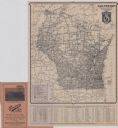
| Date: | 1970 |
|---|---|
| Description: | This colored map displays a brief description of tourist attractions in the state, as well as a grid of state parks and recreational facilities. There is a... |
If you didn't find the material you searched for, our Library Reference Staff can help.
Call our reference desk at 608-264-6535 or email us at: