 Filter: Categories of Wisconsin Historical Images
Filter: Subject of Camping
Filter: Subject of boats and boating
Filter: Categories of Wisconsin Historical Images
Filter: Subject of Camping
Filter: Subject of boats and boating
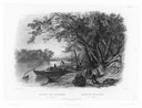
| Date: | 1832 |
|---|---|
| Description: | Travellers setting up camp along the Missouri River. |
| Date: | 05 06 1894 |
|---|---|
| Description: | Setting up camp on a bank of the Youghiogheny River. William Turville holds a canvas bag of bedding, while Jessie hands her son Fredrik a satchel from the ... |
| Date: | 02 02 1963 |
|---|---|
| Description: | Advertising photograph of a Scout Camper with "bed 'wings' extended." A woman is pouring coffee at the back door, and outside a man by a canoe is readying ... |

| Date: | 1930 |
|---|---|
| Description: | Pictorial map of Glacier National Park, Montana and Waterton Lakes National Park, Alberta. Illustrated by Joe Scheurle, it depicts white people, American ... |

| Date: | 1930 |
|---|---|
| Description: | The back of the pictorial map titled Recreational Map of Glacier National Park, Montana: Waterton Lakes National Park, Alberta. 14 panels of text and photo... |
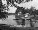
| Date: | 1930 |
|---|---|
| Description: | Campgrounds at the Island Resort, located 25 miles west of the Wisconsin Dells. |

| Date: | 1975 |
|---|---|
| Description: | A tourist map of Grant County that displays the various activities and attractions found in the cities throughout the county, such as boat landings, fishin... |

| Date: | 1926 |
|---|---|
| Description: | A brochure with a map of Interstate Park on the Dalles of the Saint Croix River, showing locations of the north and south camp grounds, the fish hatcheries... |
| Date: | 1942 |
|---|---|
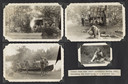
| Description: | Page from a scrapbook kept by Neighborhood House, with highlights of the boys summer camp at Camp America Williams: "backwards" day, with a line of boys dr... |

| Date: | 1964 |
|---|---|
| Description: | This 1964 maps shows roads, boat landings and marinas, campgrounds, canoe trails and portages, and lakes and streams in parts of Vilas, Oneida, and Iron co... |
| Date: | |
|---|---|
| Description: | The measure of solitude fades in the ripples and there are more prizes than there are fish |
| Date: | |
|---|---|
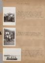
| Description: | Page from Joy Camps photo album displaying four photographs. Original caption notes: "Scenes from camp craft activities during 1940..." (the remainder of t... |

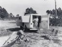
| Date: | 02 04 1963 |
|---|---|
| Description: | International Scout De Luxe Camper promotional image. A woman is standing at the open back door pouring a cup of coffee. A man is looking up at her while w... |
| Date: | |
|---|---|
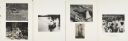
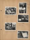
| Description: | Page from Sue Ann Hackett Scrapbook displaying several camp photographs. Includes the "Riding Committee meeting" (including the Dalmatian "Lindy"), campers... |

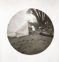
| Date: | 1910 |
|---|---|
| Description: | View along shoreline towards White City, a group of white camping tents, pitched along the Chippewa River. People are in boats near the shoreline. Caption ... |

| Date: | 1926 |
|---|---|
| Description: | This brochure was intended for tourists and shows resorts, lakes and railroads in northwestern Wisconsin and part of Michigan’s upper peninsula. Also inclu... |

| Date: | 1975 |
|---|---|
| Description: | This map shows boundaries, roads, national forest land, bogs and wetlands, lakes, campgrounds, and boat landings. |

| Date: | 1962 |
|---|---|
| Description: | This map shows roads, golf courses, ski areas, boat landings, camp sites, waysides, parks, beaches, scenic views, virgin timber tracts, airports, boys and ... |

| Date: | 1962 |
|---|---|
| Description: | This map shows roads, golf courses, ski areas, boat landings, camp sites, waysides, parks, beaches, scenic views, virgin timber tracts, airports, boys and ... |

| Date: | 1990 |
|---|---|
| Description: | This map shows various types of trails, boat landings, canoe areas, public beaches, picnic areas, campgrounds, golf courses, public tennis courts, and othe... |
If you didn't find the material you searched for, our Library Reference Staff can help.
Call our reference desk at 608-264-6535 or email us at: