 Filter: Categories of Wisconsin Historical Images
Filter: Subject of Camping
Filter: Reproduction Rights of For Sale
Filter: Categories of Wisconsin Historical Images
Filter: Subject of Camping
Filter: Reproduction Rights of For Sale
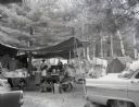
| Date: | 1960 |
|---|---|
| Description: | A campsite at Hiawatha National Forest. Men and women sits at a picnic table, while children sit by the campfire. |

| Date: | 1960 |
|---|---|
| Description: | Three men holding archery equipment at a campsite in Hiawatha National Forest. |
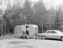
| Date: | 1960 |
|---|---|
| Description: | Two men, a woman, and a dog at a trailer in Hiawatha National Forest. |
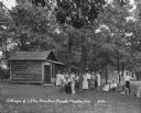
| Date: | 1930 |
|---|---|
| Description: | A group of men and women pose on the lawn outside their cottages at the Little Mountain Resort. |

| Date: | 1929 |
|---|---|
| Description: | The entrance way to the Evergreen Resort. The sign advertises rooms, hot and cold water baths, meals, camp sites, and tourist kitchens. Caption reads: "Eve... |
| Date: | 1930 |
|---|---|
| Description: | Campgrounds at the Island Resort, located 25 miles west of the Wisconsin Dells. |

| Date: | 1925 |
|---|---|
| Description: | A log cabin and park car at the Tourist Free Camp Ground. The cabin has a sign that reads, "New Glarus Settled 1845." |
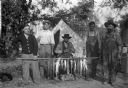
| Date: | 1910 |
|---|---|
| Description: | Five fishermen are posing in front of a tent with a long pole of sturgeon. A dog can partially be seen sitting on the ground on the left. |

| Date: | 1975 |
|---|---|
| Description: | A tourist map of Grant County that displays the various activities and attractions found in the cities throughout the county, such as boat landings, fishin... |

| Date: | 1926 |
|---|---|
| Description: | A brochure with a map of Interstate Park on the Dalles of the Saint Croix River, showing locations of the north and south camp grounds, the fish hatcheries... |

| Date: | 1910 |
|---|---|
| Description: | Group portrait of two dogs and five men. In the background are tents among trees. Two of the men are holding a pole strung with their fish catch. |
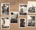
| Date: | 1930 |
|---|---|
| Description: | Page from the Tansy Camp Fire Girls album kept by Neighborhood House, with groups of girls posing at the end of a pier, in front of tents, on the remains o... |

| Date: | 1990 |
|---|---|
| Description: | A tourist map of Lafayette County, Wisconsin, that shows the locations of motels, camping, municipal parks, cheese factory tours, waysides, and golf course... |
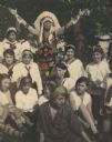
| Date: | 1930 |
|---|---|
| Description: | Hand-colored group portrait of Camp Fire girls and a man dressed in Ojibwa-style floral embroidered/beaded clothing and a Plains Indian feathered headdress... |
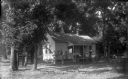
| Date: | |
|---|---|
| Description: | Eight men are posing outside the porch of a cottage which is surrounded by trees. There are blankets and clothes hanging on the clothesline. A work table w... |
| Date: | 1942 |
|---|---|
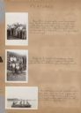
| Description: | Page from a scrapbook kept by Neighborhood House, with highlights of the boys summer camp at Camp America Williams: "backwards" day, with a line of boys dr... |
| Date: | 07 1942 |
|---|---|
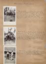
| Description: | Page from a scrapbook kept by Neighborhood House, with images from an archery tournament at a summer camp for boys at Camp America Williams: a group of fin... |
| Date: | 07 1942 |
|---|---|
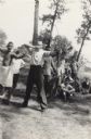
| Description: | Image from a scrapbook kept by Neighborhood House, with Pat McCann, the last shooter in an archery tournament held at a boys summer camp, drawing the bow a... |

| Date: | 07 1942 |
|---|---|
| Description: | Image from a scrapbook kept by Neighborhood House of a boys summer camp, with an image of Skip Sul?(obscured letters) participating in a game involving tak... |

| Date: | 1964 |
|---|---|
| Description: | This 1964 maps shows roads, boat landings and marinas, campgrounds, canoe trails and portages, and lakes and streams in parts of Vilas, Oneida, and Iron co... |
If you didn't find the material you searched for, our Library Reference Staff can help.
Call our reference desk at 608-264-6535 or email us at: