 Filter: Categories of Wisconsin Historical Images
Filter: Subject of Cable cars (Streetcars)
Filter: Subject of neighborhoods
Filter: Categories of Wisconsin Historical Images
Filter: Subject of Cable cars (Streetcars)
Filter: Subject of neighborhoods
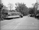
| Date: | 05 15 1931 |
|---|---|
| Description: | A streetcar was knocked off the tracks in an accident with an automobile at the corner of Mills and Drake Streets. |
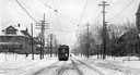
| Date: | |
|---|---|
| Description: | View down snow-covered streetcar tracks towards a streetcar traveling up an unidentified residential street in Milwaukee. |
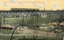
| Date: | 1911 |
|---|---|
| Description: | Elevated view across valley toward a streetcar viaduct on the Waukesha Interurban Line, near Milwaukee. Caption reads: "Street Car Bridge on Waukesha Inter... |

| Date: | |
|---|---|
| Description: | A street cleaner sweeps the tracks in a residential neighborhood, as the streetcar and its operator and passengers wait. Original Falk caption reads, "Phot... |
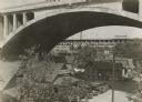
| Date: | 1940 |
|---|---|
| Description: | Small neighborhood of the city at the west end of the Menomonee River Valley. Overhead is the second Wisconsin Avenue Viaduct, demolished in 1992. Cars a... |

| Date: | 1938 |
|---|---|
| Description: | View of the Grand Avenue viaduct and surrounding establishments. A line of automobiles are parked outside a tavern under the viaduct. |
| Date: | |
|---|---|
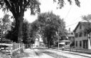
| Description: | View down Elmer Avenue, taken from the middle of the street. A street car and carriage are moving along the street; the car moves away from the camera, and... |
| Date: | |
|---|---|
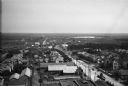
| Description: | Elevated view looking out across town buildings to a plain beyond. The Hill County Jail can be seen to the right of the main street; it was constructed in ... |
| Date: | |
|---|---|
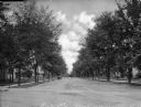
| Description: | View down a residential street lined with picket fences. An automobile and trolley car travel down the road. Published by H.C. Branch, Webster, Massachus... |

| Date: | 1906 |
|---|---|
| Description: | This map shows ward boundaries, subdivisions, lot and block numbers and dimensions, house numbers, electric car lines, steam railways, and adjoining plat n... |
If you didn't find the material you searched for, our Library Reference Staff can help.
Call our reference desk at 608-264-6535 or email us at: