 Filter: Categories of Wisconsin Historical Images
Filter: Subject of Cable cars (Streetcars)
Filter: County of Milwaukee
Filter: Year of 1900-1999
Filter: Categories of Wisconsin Historical Images
Filter: Subject of Cable cars (Streetcars)
Filter: County of Milwaukee
Filter: Year of 1900-1999
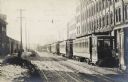
| Date: | 1900 |
|---|---|
| Description: | Streetcars are lined up in front of the buildings on the right. On the left people are walking down the sidewalk. A poster hangs from the front of the trol... |
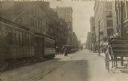
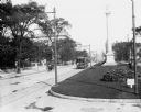
| Date: | 1900 |
|---|---|
| Description: | Looking down Grand Avenue to West Wisconsin Åvenue. Cable cars are on the left , and a carriage on right near curb. Pedestrians are crossing the street and... |
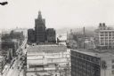
| Date: | 1920 |
|---|---|
| Description: | Elevated view over roofs, with the Milwaukee River in the background. |
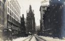
| Date: | 1917 |
|---|---|
| Description: | Looking down Grand Avenue to the east. The road is lined with automobiles, and cable car tracks are on the snow-covered street. A sign for Gimbel's is on t... |
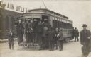
| Date: | 1910 |
|---|---|
| Description: | Men piling into an electric trolley with a sign that reads: "Viaduct". The streetcar has grating on the end, which several men are standing on. A sign on a... |

| Date: | 06 09 1939 |
|---|---|
| Description: | Elevated view of Milwaukee County Court House, with a tree-filled park area in the foreground and the city in the background. There is debris on the roof, ... |

| Date: | 1938 |
|---|---|
| Description: | View of the Grand Avenue viaduct and surrounding establishments. A line of automobiles are parked outside a tavern under the viaduct. |
| Date: | 09 1900 |
|---|---|
| Description: | View down Grand Avenue. Near a streetcar is the city's Civil War memorial, erected in 1898 by John Conway. |
| Date: | 09 1900 |
|---|---|
| Description: | View down Grand Avenue. A streetcar and a horse-drawn wagon are coming up the avenue. There are monuments in the median. |

| Date: | 1931 |
|---|---|
| Description: | This map is an advertisement for Milwaukee street cars and motor buses and reads: "Ride the street car or motor bus. Economical, safe, dependable." Include... |

| Date: | 1906 |
|---|---|
| Description: | This map shows ward boundaries, subdivisions, lot and block numbers and dimensions, house numbers, electric car lines, steam railways, and adjoining plat n... |

| Date: | 1906 |
|---|---|
| Description: | This map shows ward boundaries, lot and block numbers and dimensions, house numbers, electric car lines, steam railways, and adjoining plat numbers in a po... |
If you didn't find the material you searched for, our Library Reference Staff can help.
Call our reference desk at 608-264-6535 or email us at: