 Filter: Categories of Wisconsin Historical Images
Filter: Subject of Business
Filter: Categories of Wisconsin Historical Images
Filter: Subject of Business

| Date: | 1987 |
|---|---|
| Description: | This pictorial map shows roads, bridges, local businesses with phone numbers, and public buildings. Relief is shown pictorially. Also included is a calen... |

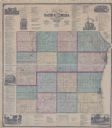
| Date: | 1858 |
|---|---|
| Description: | This map is hand-colored and mounted on cloth and shows lot and block numbers and dimensions, landownership, streets, railroads, selected buildings, fair g... |
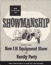
| Date: | 1953 |
|---|---|
| Description: | Cover of booklet on how to promote new International Harvester equipment with an equipment show and family party, and how to put them together for profit. ... |

| Date: | 04 21 1961 |
|---|---|
| Description: | Five attendees at the eighth annual convention of the Wisconsin division of the Future Business Leaders of America include, left to right: Russell Meyer, J... |

| Date: | 1968 |
|---|---|
| Description: | Three maps that show local streets, roads, railroads, parks, country clubs, the University of Wisconsin, Shorewood Hills, Maple Bluff, Monona, Truax Field,... |

| Date: | 06 05 1961 |
|---|---|
| Description: | Two men and a woman posing with Bergman's Pharmacy check (?). |

| Date: | 1962 |
|---|---|
| Description: | This blue print map shows 5 zoning districts, as well as lot and block numbers and dimensions, public land, streets, and Mill Pond. The zones are: "Single ... |

| Date: | 1875 |
|---|---|
| Description: | This plat map shows local streets, buildings, numbered blocks and lots, part of the Red Cedar River, and land ownership by name. Also included is a busines... |

| Date: | 11 21 1950 |
|---|---|
| Description: | This map shows agricultural, residence, business, and industrial districts as well as lot and block numbers. |

| Date: | 09 05 1961 |
|---|---|
| Description: | Mrs. Leslie (Caroline C.) Jungbluth studies The State Journal market page. Now a homemaker, she first got interested in stocks when she worked for the tele... |

| Date: | 10 03 1961 |
|---|---|
| Description: | The Madison Chapter of Certified Public Accountants, donate about three nights of work a week to auditing the United Givers fund. Among them are Donald Nel... |

| Date: | 1903 |
|---|---|
| Description: | This blue line print map is oriented with the north to the left and shows buildings with dimensions, utilities, and proposed buildings. The Flambeau River ... |

| Date: | 1857 |
|---|---|
| Description: | This map shows roads, railroads, lakes, and land ownership by name. Also included are illustrations of select business and residences, business directories... |

| Date: | 01 01 1874 |
|---|---|
| Description: | Two-page spread from H.H. Bennett's studio inventory of 1874. The spread shows the inventory and value of items in the printing and furnishing room and on ... |

| Date: | 04 21 1964 |
|---|---|
| Description: | Two women employees of the Madison Chamber of Commerce office inspecting a newly published map of Madison. They are Beverly Robinson (left) administrative ... |

| Date: | 1950 |
|---|---|
| Description: | Inside spread illustration of the world, with a legend indicating: Subsidiary Company, Branch of Subsidiary, Representative, Works, and Distributor. |
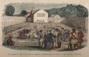
| Date: | 1859 |
|---|---|
| Description: | Hand-colored engraving showing fur company agents making a distribution of goods to Indians, some of whom are seated on the ground, in a fenced courtyard w... |
| Date: | 1873 |
|---|---|
| Description: | This hand-colored map includes business directories, a statistical table, as well as illustrations of public, residential, and commercial properties. Commu... |

| Date: | 1861 |
|---|---|
| Description: | This map shows townships and sections, landownership, roads, railroads, rural residences, schools, churches, and topography. Also included are inset maps o... |

| Date: | 04 28 1965 |
|---|---|
| Description: | The Wisconsin Chapter of the American Business Women's Assn. (ABWA) holds its annual "Boss Night" dinner at the Top Hat Supper Club in Middleton. Shown (se... |
If you didn't find the material you searched for, our Library Reference Staff can help.
Call our reference desk at 608-264-6535 or email us at: