 Filter: Categories of Wisconsin Historical Images
Filter: Subject of Business
Filter: Categories of Wisconsin Historical Images
Filter: Subject of Business

| Date: | 1876 |
|---|---|
| Description: | This 1876 map of Saint Croix County, Wisconsin, shows the township and range grid, sections, towns, cities and villages, land ownership and acreages, wagon... |

| Date: | 1877 |
|---|---|
| Description: | This 1877 map of Trempealeau County, Wisconsin, shows the township and range grid, sections, towns, cities and villages, land ownership and acreages, roads... |

| Date: | 1878 |
|---|---|
| Description: | This 1878 map of Vernon County, Wisconsin, shows the township and range grid, sections, towns, cities and villages, land ownership and acreages, roads, rai... |

| Date: | 1860 |
|---|---|
| Description: | This map of Dodge County, Wisconsin, shows the township and range grid, towns, sections, cities and villages, railroads, roads, property owners and acreage... |

| Date: | 1896 |
|---|---|
| Description: | This late 19th-century map of Dodge County, Wisconsin, shows the township and range grid, towns, sections, cities, villages and post offices, some property... |

| Date: | 1904 |
|---|---|
| Description: | Map shows townships and sections, landownership and acreages, roads and railroads, and selected buildings. "1904" inscribed on map in pen. Includes busines... |

| Date: | 1967 |
|---|---|
| Description: | This tourist brochure for Forest County, Wisconsin, includes a 1967 road map of the county which identifies points of interest, a location map, descriptive... |

| Date: | 1876 |
|---|---|
| Description: | Map shows landownership and acreages, roads and railroads, and some buildings. Includes illustrations of local buildings, business directories, and tables ... |
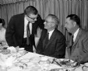
| Date: | 01 31 1957 |
|---|---|
| Description: | William E. Brobst, center, master of ceremonies, at a farewell dinner for 20 members of the Pure Oil Co. Madison office who are leaving the company or are ... |
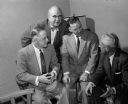
| Date: | 01 31 1957 |
|---|---|
| Description: | Left to right are: James Meyers, Martin Bliese, Ole Gunderson, and Keith Blechlin, all of whom are being transferred from the Madison Pure Oil Co. office. |
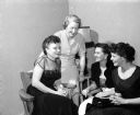
| Date: | 01 31 1957 |
|---|---|
| Description: | Mrs. Jack McCarron (left), Mae Boyd, Mrs. Irv Skoyen and Mrs. D.W. Kirner, employees of the Pure Oil Co. Madison office, are leaving the company or being t... |

| Date: | 01 31 1957 |
|---|---|
| Description: | Group portrait of four of the twenty employees staying in Madison with the Pure Oil Co. They include, from left: Knowlton Levernick, H.C. Hoff, J.M. Beveri... |

| Date: | 1961 |
|---|---|
| Description: | Map of the Town of Preble, Brown County, Wisconsin, showing land ownership by name, subdivisions, roads and streets, railroads, and local businesses. |

| Date: | 04 26 1957 |
|---|---|
| Description: | Janice Reed and Bill Kellesvig reigned as queen and king of the annual Prom of Madison Business College students. The party was held at the East Side Busin... |

| Date: | 04 26 1957 |
|---|---|
| Description: | Two couples attending the Prom were Bruce and Audrey Steinmetz, left, and Marie and LaVern Weisensel. |

| Date: | 04 26 1957 |
|---|---|
| Description: | The original caption reads: "These four students of the college are apparently enjoying the fruit punch. They are Gerald Newman, Jan Franz, Jack Miller, an... |

| Date: | 04 26 1957 |
|---|---|
| Description: | Chatting between dances at the Madison Business College Spring Prom are Marvin Frisch, Ted Herpel, Sharon Wendt, and Alice Schoeberie. |

| Date: | 05 22 1957 |
|---|---|
| Description: | Ron Ross, president of the Tri-Association Council of the East Side Business Men's Association, the West Side Business Men's Association and the South Side... |

| Date: | 1873 |
|---|---|
| Description: | This 1873 map of Winnebago County, Wisconsin, shows the township and range grid, towns, sections, cities and villages, landownership and acreages, roads, r... |

| Date: | 1877 |
|---|---|
| Description: | Shows land ownership by name, churches, schools, farm houses, wagon roads, railroads. Includes directory of businesses for Columbus, Portage, Doylestown, W... |
If you didn't find the material you searched for, our Library Reference Staff can help.
Call our reference desk at 608-264-6535 or email us at: