 Filter: Categories of Wisconsin Historical Images
Filter: Subject of Business
Filter: Categories of Wisconsin Historical Images
Filter: Subject of Business

| Date: | 1910 |
|---|---|
| Description: | A business map of Wisconsin, showing railroads, counties, cities, villages, rivers, lakes, and electric lines. Additional areas also included in the map ar... |

| Date: | 1911 |
|---|---|
| Description: | A business atlas map of Wisconsin, showing the railroads, counties, cities, villages, rivers, lakes, electric lines, and steamship lines in the state. Othe... |
| Date: | 1911 |
|---|---|
| Description: | Front cover of International Harvester Company's annual report. |

| Date: | 09 07 1976 |
|---|---|
| Description: | Letter on Frackelton & Co. letterhead regarding a business transaction between Frackelson & Co. and Lawson & Goodnow Manufacturing Co. of New York. |

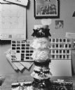
| Date: | |
|---|---|
| Description: | A woman dressed in a costume that would appear to represent businesses and products of Wisconsin. Her very tall hat has a world globe on the top and the wo... |

| Date: | 09 14 1922 |
|---|---|
| Description: | Document certifying that articles of incorporation for Green Bay Football Club were received by the Register of Deeds and filed with the Department of Stat... |

| Date: | 09 18 1922 |
|---|---|
| Description: | Certificate naming the officers of the Green Bay Football Club: President, E.L. Lambeau (Earl "Curly" Lambeau); Vice President, Joseph M. Ordens; Treasurer... |

| Date: | 01 09 1957 |
|---|---|
| Description: | Group portrait of the new officers of the West Side Businessmen's auxiliary. Seated left to right: Caroline Blawusch, Harriet Williams, Ruth Egan. Standing... |

| Date: | 1955 |
|---|---|
| Description: | Bottom of the map reads: "PARKING AREA STUDY MILWAUKEE COUNTY ZOOLOGICAL GARDEN SCALE 1"=200" APRIL 21, 1955 TOTAL PARKING AREA - 3736 CARS 31.1 acres". Th... |
| Date: | 12 20 1992 |
|---|---|
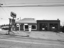
| Description: | "In early December, Theresa residents were notified that the Shefond Oil Co. was closing the last service station in the community. At one time gas could b... |

| Date: | 12 20 1992 |
|---|---|
| Description: | "In early December, Theresa residents were notified that the Shefond Oil Co. was closing the last service station in the community. At one time gas could b... |

| Date: | 04 10 1957 |
|---|---|
| Description: | Portrait of Jacqueline Miller, seated at a desk typing a job resume. |

| Date: | 1879 |
|---|---|
| Description: | A map of Jackson County, Wisconsin, shows the township and section survey, landownership, towns, villages, buildings, roads, railroads, county land, and st... |
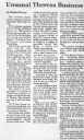
| Date: | |
|---|---|
| Description: | View of an article on Theresa's "best kept secret," Custom Accessories, a manufacturer of garters for the wedding industry. |
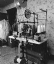
| Date: | 09 16 1997 |
|---|---|
| Description: | "The Ward Allen's use this equipment to manufacture their very attractive garters." |
| Date: | 09 16 1997 |
|---|---|
| Description: | "Here are some of the Allen creations. The photo on the wall shows Ward Allen as a former Channel 6 weather forecaster, holding his favorite prop, 'Albert ... |

| Date: | |
|---|---|
| Description: | "This band is made specifically for Harley Davidson 'Hog' riders." |

| Date: | 04 1998 |
|---|---|
| Description: | "Flags were flown at half-staff at Michels Pipeline Construction Inc., when it was learned that founder Dale Michels had passed away." |

| Date: | 1970 |
|---|---|
| Description: | A map showing highlighted snowmobile trails, ice crossings, and supporting businesses in the towns of Stephenson and Silver Cliff in Marinette County and ... |

| Date: | 1877 |
|---|---|
| Description: | A map of Monroe County, Wisconsin that shows the townships and landownership and acreage wagon roads, railroads, streams, schools, and houses. Also include... |
If you didn't find the material you searched for, our Library Reference Staff can help.
Call our reference desk at 608-264-6535 or email us at: