 Filter: Categories of Wisconsin Historical Images
Filter: Subject of Business
Filter: Year of 1800-1899
Filter: Year of 1850-1859
Filter: Categories of Wisconsin Historical Images
Filter: Subject of Business
Filter: Year of 1800-1899
Filter: Year of 1850-1859
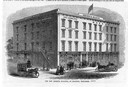
| Date: | 1853 |
|---|---|
| Description: | Illustration of the new museum building, also known as "Bruen's Block," on the corner of East Washington Avenue and South Pinckney Street. Named for W.D. B... |

| Date: | 1858 |
|---|---|
| Description: | This 1858 map of Rock County, Wisconsin, shows the township and range grid, towns, sections, cities and villages, railroads, roads, property owners and res... |
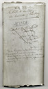
| Date: | 1852 |
|---|---|
| Description: | Assembly bill 175 which legalized the business of banking in Wisconsin. |
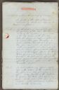
| Date: | 1852 |
|---|---|
| Description: | First page of Assembly Bill 175 approving the business of banking in Wisconsin. |

| Date: | 1855 |
|---|---|
| Description: | This map shows lot and block numbers, buildings, some landownership, roads, railroads, cemeteries, the Milwaukee River, and Lake Michigan. The map includes... |

| Date: | 1858 |
|---|---|
| Description: | This map is hand-colored and mounted on cloth and shows lot and block numbers and dimensions, landownership, streets, railroads, selected buildings, fair g... |

| Date: | 1857 |
|---|---|
| Description: | This map shows roads, railroads, lakes, and land ownership by name. Also included are illustrations of select business and residences, business directories... |
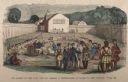
| Date: | 1859 |
|---|---|
| Description: | Hand-colored engraving showing fur company agents making a distribution of goods to Indians, some of whom are seated on the ground, in a fenced courtyard w... |
If you didn't find the material you searched for, our Library Reference Staff can help.
Call our reference desk at 608-264-6535 or email us at: