 Filter: Categories of Wisconsin Historical Images
Filter: Subject of Business
Filter: Subject of human settlements
Filter: Subject of transportation
Filter: Creator Name of Unknown
Filter: Categories of Wisconsin Historical Images
Filter: Subject of Business
Filter: Subject of human settlements
Filter: Subject of transportation
Filter: Creator Name of Unknown
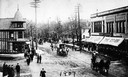
| Date: | 1907 |
|---|---|
| Description: | Elevated view of a costume parade on State Street, at the corner of State Street and Gilman Street. On both sides of the street are drugstores. The one on ... |
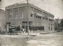
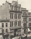
| Date: | 1920 |
|---|---|
| Description: | Brick building containing the Olaf Noer Drugstore. A man (presumably Mr. Noer himself) poses in the doorway. |
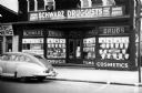
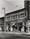
| Date: | 01 14 1944 |
|---|---|
| Description: | Exterior view of Schwarz Druggists, Inc. |
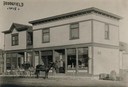
| Date: | 1910 |
|---|---|
| Description: | View of storefront and people with a horse-drawn carriage. |
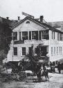
| Date: | 1900 |
|---|---|
| Description: | Four-level building with shorter buildings flanking it on either side. On the road in front two carriages are visible, drawn by horses. A group of men ar... |
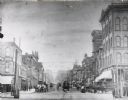
| Date: | 1900 |
|---|---|
| Description: | Previously known as Chestnut Street; view from the corner of 3rd Street. Image looks down the road to the vanishing point on the horizon, where a steeple ... |
| Date: | 1880 |
|---|---|
| Description: | It was in this shop that Christopher Sholes, inventor of the typewriter, did much of his work on various inventions. This photograph may be as early as th... |
| Date: | 1935 |
|---|---|
| Description: | Skilled Trade Division, at 511-A West Wells Street, Lot 1119. Men's Department-Skilled Trade and Clerical Division; Division for the Physically Disabled. ... |

| Date: | 1970 |
|---|---|
| Description: | A map showing highlighted snowmobile trails, ice crossings, and supporting businesses in the towns of Stephenson and Silver Cliff in Marinette County and ... |

| Date: | 1877 |
|---|---|
| Description: | A map of Monroe County, Wisconsin that shows the townships and landownership and acreage wagon roads, railroads, streams, schools, and houses. Also include... |

| Date: | 1966 |
|---|---|
| Description: | This 1966 map shows topography, roads, highways, golf courses, government buildings, and businesses around Delavan Lake in Walworth County, Wisconsin. Incl... |

| Date: | 1836 |
|---|---|
| Description: | This map shows settlers houses and businesses, trails, and swamps. The relief is shown by hachures. The map includes illustrations of historical buildings ... |

| Date: | 05 1958 |
|---|---|
| Description: | Photocopy of a map created by the City of Milwaukee Master Plan Program City Planning Division in May of 1958 representing 1870 "THE CENTRAL AREA OF THE CI... |

| Date: | 1940 |
|---|---|
| Description: | Map features advertisements for local businesses on the left and bottom. Map includes a "LEGEND" and "DIRECTORY OF CHURCHES". Streets are labeled as are so... |

| Date: | 1900 |
|---|---|
| Description: | Pen and pencil on tracing paper. Shows landownership by name, local streets, local businesses, mill pond, creek, and proposed railroad. |

| Date: | 1920 |
|---|---|
| Description: | Map shows townships and sections, landownership and acreages, roads, and railroads in southwest portion of Marinette County. Sections of the map are in ye... |

| Date: | 1890 |
|---|---|
| Description: | This map of Superior shows city wards, bays, docks, some businesses and points of interest. Relief is shown by hachures. The back of the map features a typ... |

| Date: | 1898 |
|---|---|
| Description: | This map of Superior shows city wards, bays, docks, and some businesses and points of interest. Relief is shown by hachures. The map probably came from a C... |

| Date: | 1931 |
|---|---|
| Description: | This map of Ashland shows roads, railroads, and local businesses. The map reads: "Showing streets and roads open to the public Oct. 1, 1931." Included on t... |

| Date: | 1858 |
|---|---|
| Description: | This map is hand-colored and mounted on cloth and shows lot and block numbers and dimensions, landownership, streets, railroads, selected buildings, fair g... |
If you didn't find the material you searched for, our Library Reference Staff can help.
Call our reference desk at 608-264-6535 or email us at: