 Filter: Categories of Wisconsin Historical Images
Filter: Subject of Business
Filter: Subject of human settlements
Filter: Subject of learning and scholarship
Filter: Categories of Wisconsin Historical Images
Filter: Subject of Business
Filter: Subject of human settlements
Filter: Subject of learning and scholarship

| Date: | 1860 |
|---|---|
| Description: | This map of Dodge County, Wisconsin, shows the township and range grid, towns, sections, cities and villages, railroads, roads, property owners and acreage... |
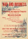
| Date: | 1918 |
|---|---|
| Description: | Poster with red text overlaying illustrations in blue. The top left illustration is of soldiers with cannons on battlefront. At the bottom right is an illu... |
If you didn't find the material you searched for, our Library Reference Staff can help.
Call our reference desk at 608-264-6535 or email us at: