 Filter: Categories of Wisconsin Historical Images
Filter: Subject of Business
Filter: Reproduction Rights of For Sale
Filter: Subject of human settlements
Filter: County of Dane
Filter: Categories of Wisconsin Historical Images
Filter: Subject of Business
Filter: Reproduction Rights of For Sale
Filter: Subject of human settlements
Filter: County of Dane
| Date: | 1907 |
|---|---|
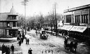
| Description: | Elevated view of a costume parade on State Street, at the corner of State Street and Gilman Street. On both sides of the street are drugstores. The one on ... |
| Date: | 1925 |
|---|---|
| Description: | The corner of State and Fairchild Streets showing Yost-Kessnich's and the Capitol Theatre under construction. |
| Date: | 1905 |
|---|---|
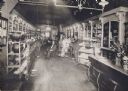
| Description: | Interior view of Sumner's Drugstore, which was established in 1855. From left to right are George "Jud" Stone, Edwin Sumner, and Bert B. Collyer. |
| Date: | 1910 |
|---|---|
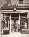
| Description: | Exterior view of A.H. Hollister's Pharmacy, which was located at 3 North Pinckney Street. The man with the long beard (far left), is Albert H. Hollister (1... |
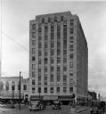
| Date: | 1934 |
|---|---|
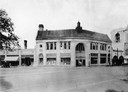
| Description: | View of the front face of the Tenney Building, corner of Pinckney and Main Streets, on the Capitol Square. Liggetts Drug Store occupies a portion of the lo... |
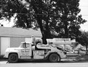
| Date: | 07 24 1960 |
|---|---|
| Description: | A mobile silage processing equipment truck owned by the Black Earth Farm Service company. |
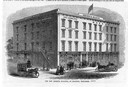
| Date: | 1853 |
|---|---|
| Description: | Illustration of the new museum building, also known as "Bruen's Block," on the corner of East Washington Avenue and South Pinckney Street. Named for W.D. B... |
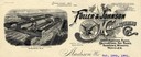
| Date: | 1901 |
|---|---|
| Description: | Fuller & Johnson Manufacturing letterhead. Fuller & Johnson was run by John A. Johnson and was one of Madison's largest employers. |

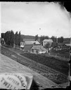
| Date: | 1874 |
|---|---|
| Description: | Distant view of the town from a hill with houses, garden plots, businesses and churches. |
| Date: | 1877 |
|---|---|
| Description: | A view from the roof across an unpaved road towards a building across the street from A.L. Dahl's photography studio. The two-story storefront is a general... |

| Date: | 1925 |
|---|---|
| Description: | View from street of three people posing in front of the printing office and shop. |

| Date: | 1929 |
|---|---|
| Description: | This map is oriented with north to the upper right. Includes index of retailers and buildings, with some advertisements in margins. |

| Date: | 1948 |
|---|---|
| Description: | Map created between 1948 and 1954. Shows businesses and lot owners around the State Capitol. Oriented with north to the upper right. Includes "continued in... |

| Date: | 1955 |
|---|---|
| Description: | Shows city limits, adjoining municipalities, and schools. Indexes, illustrations, ancillary map of Dane County, and ancillary map of Madison business secti... |

| Date: | 1968 |
|---|---|
| Description: | Three maps that show local streets, roads, railroads, parks, country clubs, the University of Wisconsin, Shorewood Hills, Maple Bluff, Monona, Truax Field,... |

| Date: | 2004 |
|---|---|
| Description: | This map shows ATMs, houses of worship, hotels, parking ramps, public parking, union cab stands, bus stops, business district, parks and public areas, gove... |

| Date: | 1914 |
|---|---|
| Description: | Twelve photographs and one letterhead are mounted on a board with captions. The photographs cover the time before and after a fire in 1909 when the company... |
If you didn't find the material you searched for, our Library Reference Staff can help.
Call our reference desk at 608-264-6535 or email us at: