 Filter: Categories of Wisconsin Historical Images
Filter: Subject of Business
Filter: Creator Name of Unknown
Filter: Categories of Wisconsin Historical Images
Filter: Subject of Business
Filter: Creator Name of Unknown

| Date: | 1940 |
|---|---|
| Description: | Map features advertisements for local businesses on the left and bottom. Map includes a "LEGEND" and "DIRECTORY OF CHURCHES". Streets are labeled as are so... |

| Date: | 1900 |
|---|---|
| Description: | Pen and pencil on tracing paper. Shows landownership by name, local streets, local businesses, mill pond, creek, and proposed railroad. |

| Date: | 1920 |
|---|---|
| Description: | Map shows townships and sections, landownership and acreages, roads, and railroads in southwest portion of Marinette County. Sections of the map are in ye... |
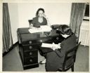
| Date: | 10 1940 |
|---|---|
| Description: | Irna Phillips sits at her desk dictating a letter to her secretary. |

| Date: | 1890 |
|---|---|
| Description: | This map of Superior shows city wards, bays, docks, some businesses and points of interest. Relief is shown by hachures. The back of the map features a typ... |

| Date: | 1898 |
|---|---|
| Description: | This map of Superior shows city wards, bays, docks, and some businesses and points of interest. Relief is shown by hachures. The map probably came from a C... |

| Date: | 1931 |
|---|---|
| Description: | This map of Ashland shows roads, railroads, and local businesses. The map reads: "Showing streets and roads open to the public Oct. 1, 1931." Included on t... |

| Date: | 1964 |
|---|---|
| Description: | This map is a hand-colored blue line print and shows 4 residence zones, 2 business zones, 1 light manufacturing zones, schools, and parks. The zones are ou... |

| Date: | |
|---|---|
| Description: | Josh Sanford, an unknown individual, and Willis Hofmeister, at Willis's Radio and Electric Service. Sanford served in the Air Force during World War II as ... |

| Date: | 1858 |
|---|---|
| Description: | This map is hand-colored and mounted on cloth and shows lot and block numbers and dimensions, landownership, streets, railroads, selected buildings, fair g... |

| Date: | 1962 |
|---|---|
| Description: | This blue print map shows 5 zoning districts, as well as lot and block numbers and dimensions, public land, streets, and Mill Pond. The zones are: "Single ... |

| Date: | 1903 |
|---|---|
| Description: | This blue line print map is oriented with the north to the left and shows buildings with dimensions, utilities, and proposed buildings. The Flambeau River ... |

| Date: | 1960 |
|---|---|
| Description: | This dot density map shows the number of shipments in 1952 throughout Wisconsin and to other United States destinations from Neillsville. Mellen, Cable, Bl... |

| Date: | 1914 |
|---|---|
| Description: | This photostat map shows Fort Winnebago around 1931, land to be reserved for military purposes, roads to Fort Howard and Fort Crawford, "private property" ... |

| Date: | 02 18 1976 |
|---|---|
| Description: | Brooks McCormick, on the left, unidentified man in center, and President Ford on the right. Brooks McCormick was attending a reception for the Business Cou... |

| Date: | 2004 |
|---|---|
| Description: | This map shows ATMs, houses of worship, hotels, parking ramps, public parking, union cab stands, bus stops, business district, parks and public areas, gove... |
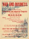
| Date: | 1918 |
|---|---|
| Description: | Poster with red text overlaying illustrations in blue. The top left illustration is of soldiers with cannons on battlefront. At the bottom right is an illu... |

| Date: | 12 18 1968 |
|---|---|
| Description: | A group of men in suits are sitting on folding chairs, looking off-camera. One man is taking notes. Some of the men have briefcases next to their chairs. C... |

| Date: | 04 1954 |
|---|---|
| Description: | Several men are standing and sitting around a desk, where one man is signing a document. A calendar for the Norris Wholesale Corporation is on the wall beh... |

| Date: | 1909 |
|---|---|
| Description: | Group portrait of men posing in front of a tent set up outdoors as temporary headquarters for Findorff after a fire. Caption reads: "After the destruction ... |
If you didn't find the material you searched for, our Library Reference Staff can help.
Call our reference desk at 608-264-6535 or email us at: