 Filter: Categories of Wisconsin Historical Images
Filter: Subject of Business
Filter: Type of Map or Atlas
Filter: Categories of Wisconsin Historical Images
Filter: Subject of Business
Filter: Type of Map or Atlas

| Date: | 1914 |
|---|---|
| Description: | This photostat map shows Fort Winnebago around 1931, land to be reserved for military purposes, roads to Fort Howard and Fort Crawford, "private property" ... |

| Date: | 1900 |
|---|---|
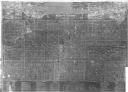
| Description: | This map shows landownership, churches, schools, farm houses, wagon roads, railroads, and townships and includes businesses advertisements, tables of stati... |
| Date: | 1878 |
|---|---|
| Description: | This map includes business directories, statistical table, distance table, list of county officers, and illustrated views of residential and commercial pro... |
| Date: | 1922 |
|---|---|
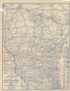
| Description: | This map shows roads, highways, lakes, rivers, county boundaries, and cities. Selected businesses are highlighted in red. Includes an explanation of state ... |

| Date: | 2004 |
|---|---|
| Description: | This map shows ATMs, houses of worship, hotels, parking ramps, public parking, union cab stands, bus stops, business district, parks and public areas, gove... |

| Date: | 1900 |
|---|---|
| Description: | This photocopy map shows blocks, lots, subdivisions, city wards, buildings, some landownership, and the Mississippi River. The map margins include business... |

| Date: | 1864 |
|---|---|
| Description: | This map shows land owners, buildings, cities and villages, lakes, rivers, and roads. The margins include inset maps: Berlin; Mill Point; Holland; Ferrisvi... |
If you didn't find the material you searched for, our Library Reference Staff can help.
Call our reference desk at 608-264-6535 or email us at: