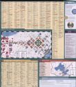
| Date: | 1929 |
|---|---|
| Description: | This map is oriented with north to the upper right. Includes index of retailers and buildings, with some advertisements in margins. |

| Date: | 1948 |
|---|---|
| Description: | Map created between 1948 and 1954. Shows businesses and lot owners around the State Capitol. Oriented with north to the upper right. Includes "continued in... |

| Date: | 1955 |
|---|---|
| Description: | Shows city limits, adjoining municipalities, and schools. Indexes, illustrations, ancillary map of Dane County, and ancillary map of Madison business secti... |

| Date: | 1968 |
|---|---|
| Description: | Three maps that show local streets, roads, railroads, parks, country clubs, the University of Wisconsin, Shorewood Hills, Maple Bluff, Monona, Truax Field,... |

| Date: | 2004 |
|---|---|
| Description: | This map shows ATMs, houses of worship, hotels, parking ramps, public parking, union cab stands, bus stops, business district, parks and public areas, gove... |
If you didn't find the material you searched for, our Library Reference Staff can help.
Call our reference desk at 608-264-6535 or email us at: