 Filter: Categories of Wisconsin Historical Images
Filter: Subject of Buildings
Filter: Community of Prairie du Chien
Filter: Categories of Wisconsin Historical Images
Filter: Subject of Buildings
Filter: Community of Prairie du Chien

| Date: | 1900 |
|---|---|
| Description: | This photocopy map shows proposed buildings and building use at Fort Crawford. |

| Date: | 1900 |
|---|---|
| Description: | This photocopy map shows marshes, woods, buildings, and selected features including islands, mounds, old Fort Crawford, and "new site for a fort in questio... |
| Date: | 1930 |
|---|---|
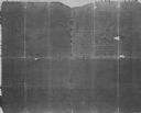
| Description: | This photocopy map includes cross section of buildings. |
| Date: | |
|---|---|
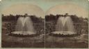
| Description: | Stereograph of Artesian well. A stone wall surrounds the well, with an observation area beyond. Groups of visitors are milling about and a drive with horse... |
| Date: | |
|---|---|
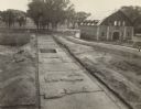
| Description: | Elevated view of Fort Crawford facing west showing north row of buildings. The Mississippi River is in the background. Typewritten caption reads: "Fort Cra... |
| Date: | |
|---|---|
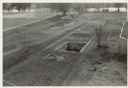
| Description: | Completed excavations at Fort Crawford showing the north row of buildings. Caption reads: "N. Row Bldgs. Completed excavations, Ft. Crawford." |
If you didn't find the material you searched for, our Library Reference Staff can help.
Call our reference desk at 608-264-6535 or email us at: