 Filter: Categories of Wisconsin Historical Images
Filter: Subject of Building sites
Filter: Subject of roads
Filter: Categories of Wisconsin Historical Images
Filter: Subject of Building sites
Filter: Subject of roads

| Date: | 1955 |
|---|---|
| Description: | Aerial view of Midvale neighborhood under construction near Madison's southwestern city limits. The view is focused on the area bounded by Tokay Boulevard,... |
| Date: | 1952 |
|---|---|
| Description: | Watercolor painting of a Wolff-Kubly & Hirsig building (the site of the current Wisconsin Historical Museum) under construction. |
| Date: | 1880 |
|---|---|
| Description: | Elevated view of Rice Lake. A partially constructed building is in the right foreground. Unpaved roads and a sidewalk lead to commercial buildings and dwel... |
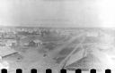
| Date: | 1954 |
|---|---|
| Description: | Panoramic view of the Mendota grade school during construction. |
| Date: | 1899 |
|---|---|
| Description: | Elevated view of group of men standing in front of construction site, near a newly completed building on Main Street, near the intersection of West Montell... |

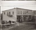
| Date: | 1905 |
|---|---|
| Description: | Elevated view of the street and construction site outside of the Plankinton House hotel and various storefronts. Along the street and sidewalks are horse-d... |
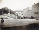
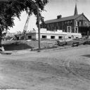
| Date: | 07 1908 |
|---|---|
| Description: | Workmen with teams of horses excavate for the new Mercantile Store, later the M.M. Smart Store. A woman is walking on the street nearby, and a boy or man w... |
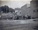
| Date: | 07 1908 |
|---|---|
| Description: | Workmen with teams of horses excavate for the new Mercantile Store, later the M.M. Smart Store. |

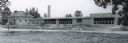
| Date: | 08 17 1950 |
|---|---|
| Description: | The Veterans Administration Hospital at 895 University Bay Drive, Shorewood Hills is shown under construction before occupation. |

| Date: | |
|---|---|
| Description: | Elevated view of the camp and valley of the site of the Elephant Butte Dam near Truth or Consequences. There are buildings, roads, railroad tracks, and tra... |
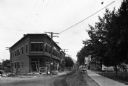
| Date: | |
|---|---|
| Description: | View down Prospect Street, a dirt road, featuring the construction of a brick corner building. Two men look on from the steps of their home across the str... |

| Date: | 03 1932 |
|---|---|
| Description: | Two International trucks exit a tunnel on a dirt road leading through a canyon during the construction of the Hoover Dam. Two men stand on the top of a squ... |

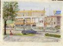
| Date: | 07 1987 |
|---|---|
| Description: | "Andy Schnitzler holds the plans for the 'River View Mobile Home Park' which will be developed in the fields behind." |
| Date: | |
|---|---|
| Description: | A man in motion moves upon good reason. To create disorder he must stop and settle down. |

| Date: | |
|---|---|
| Description: | Elevated view of a construction site. There are two men standing on a dirt road, looking down at other men down below them working around a brick wall. A w... |

| Date: | 1950 |
|---|---|
| Description: | Aerial view of the camp, including a numbered index of the buildings. Used as an application form for a forestry workshop. Founded in 1944, located at 519 ... |
| Date: | 1903 |
|---|---|
| Description: | View across unpaved road towards construction workers working on the first floor of the Eau Claire Public Library at the intersection of Farwell Street and... |

| Date: | 1769 |
|---|---|
| Description: | Map of New Orleans at the start of the French & Indian War, including two inset maps of the Mississippi River Delta and Fort la Balise. It shows streets, r... |

| Date: | 1761 |
|---|---|
| Description: | Map of New Orleans with north oriented towards the upper right corner. It shows the land around the city, the Mississippi River, anchorages, roads leading ... |
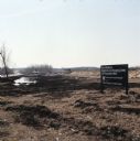
| Date: | |
|---|---|
| Description: | View of a dredged wetland area near a road. A sign along the right reads: "New Middleton Neighborhood Shopping Center Site Preparation Work." |
If you didn't find the material you searched for, our Library Reference Staff can help.
Call our reference desk at 608-264-6535 or email us at: