Filter: Categories of Wisconsin Historical Images
Filter: Subject of Building sites
Filter: Subject of rivers
Filter: Categories of Wisconsin Historical Images
Filter: Subject of Building sites
Filter: Subject of rivers

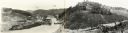
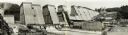
| Date: | 1911 |
|---|---|
| Description: | View towards a construction site, with people walking on a dirt road, and others working at the site. Location identified as the reconstruction following t... |

| Date: | 1769 |
|---|---|
| Description: | Map of New Orleans at the start of the French & Indian War, including two inset maps of the Mississippi River Delta and Fort la Balise. It shows streets, r... |

| Date: | 1761 |
|---|---|
| Description: | Map of New Orleans with north oriented towards the upper right corner. It shows the land around the city, the Mississippi River, anchorages, roads leading ... |
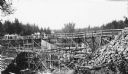
| Date: | 1936 |
|---|---|
| Description: | Two groups of men are standing on a temporary wooden bridge over the Totogatic River. There is a large form in place on the left and a complete concrete wi... |

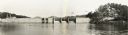
| Date: | 1940 |
|---|---|
| Description: | Aerial view, looking upstream, of water flowing through a dam. On the reverse of the print is written: "Dam built by WPA on site of old logging dam on the ... |
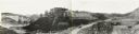
| Date: | 1935 |
|---|---|
| Description: | An elevated, panoramic view of the construction of the Norris Dam. Portions of the image are labeled. |
| Date: | 05 23 1936 |
|---|---|
| Description: | Elevated, panoramic view across water towards the Norris Dam. Portions of the image are labeled. |

| Date: | 1937 |
|---|---|
| Description: | Elevated, panoramic view of the Norris Dam from the west side of the Clinch River. |
| Date: | 1935 |
|---|---|
| Description: | Panoramic view of the construction of the Norris Dam, looking upstream. On the left the text reads: "West Bank," and on the right it reads: "East Bank." |

| Date: | 12 13 1938 |
|---|---|
| Description: | Elevated, panoramic view of the Wheeler Dam from the south side of the Tennessee River. |

| Date: | 08 01 1936 |
|---|---|
| Description: | Elevated, panoramic view of the Pickwick Dam under construction. |

| Date: | 12 05 1938 |
|---|---|
| Description: | Elevated, panoramic view from upstream towards the Guntersville Dam. |

| Date: | 02 09 1939 |
|---|---|
| Description: | Elevated, panoramic view from upstream towards the Guntersville Dam. |

| Date: | 07 23 1936 |
|---|---|
| Description: | Elevated, panoramic view of the Chickamauga Dam. |

| Date: | 03 11 1937 |
|---|---|
| Description: | Elevated, panoramic view of the Chickamauga Dam. |

| Date: | 09 14 1938 |
|---|---|
| Description: | Aerial, panoramic view towards the Chickamauga Dam. |
If you didn't find the material you searched for, our Library Reference Staff can help.
Call our reference desk at 608-264-6535 or email us at: