 Filter: Categories of Wisconsin Historical Images
Filter: Subject of Building sites
Filter: Subject of land use, urban
Filter: Subject of water
Filter: Categories of Wisconsin Historical Images
Filter: Subject of Building sites
Filter: Subject of land use, urban
Filter: Subject of water

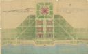
| Date: | 1917 |
|---|---|
| Description: | The Lake Forest community plan, a model community that was planned for the site where the University of Wisconsin Arboretum now stands. |

| Date: | 1958 |
|---|---|
| Description: | An aerial view of the construction of a new wing on a state office building. Automobiles are parked in a log along Lake Monona. |

| Date: | 1792 |
|---|---|
| Description: | Map of Washington D.C. Labeled on the map are all the main streets, the site of the Capitol and the President's House. The map also shows the relationship ... |
| Date: | 07 1939 |
|---|---|
| Description: | An architectural rendering of a proposed lakefront development plan. |

| Date: | 1769 |
|---|---|
| Description: | Map of New Orleans at the start of the French & Indian War, including two inset maps of the Mississippi River Delta and Fort la Balise. It shows streets, r... |

| Date: | 1761 |
|---|---|
| Description: | Map of New Orleans with north oriented towards the upper right corner. It shows the land around the city, the Mississippi River, anchorages, roads leading ... |
If you didn't find the material you searched for, our Library Reference Staff can help.
Call our reference desk at 608-264-6535 or email us at: