 Filter: Categories of Wisconsin Historical Images
Filter: Subject of Building sites
Filter: Subject of land
Filter: Subject of cities and towns
Filter: Categories of Wisconsin Historical Images
Filter: Subject of Building sites
Filter: Subject of land
Filter: Subject of cities and towns
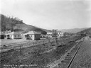
| Date: | 11 02 1918 |
|---|---|
| Description: | Residential building site near railroad tracks, looking west. Several houses are under construction. Benham was a "company town" created by International H... |
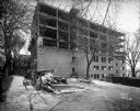
| Date: | 10 29 1934 |
|---|---|
| Description: | New employees dormitory under construction at Lake View Sanitorium. |
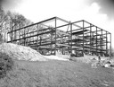
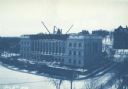
| Date: | 05 01 1931 |
|---|---|
| Description: | State Office Building, 1 W. Wilson Street, under construction. This is a side view, with two posters advertising: "10 Nights in a Barroom" at the Orpheum T... |
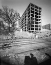
| Date: | 11 02 1930 |
|---|---|
| Description: | View of the State Office Building, 1 W. Wilson Street, under construction, from Lake Monona. The photographer's shadow and railroad tracks are in the foreg... |

| Date: | 02 03 1931 |
|---|---|
| Description: | View across railroad tracks towards the State Office Building, 1 W. Wilson Street, under construction. |

| Date: | 06 07 1930 |
|---|---|
| Description: | Basement of State Office Building, 1 W. Wilson Street, under construction, facing towards Wilson Street. |
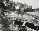
| Date: | 07 02 1930 |
|---|---|
| Description: | Basement of State Office Building, 1 W. Wilson Street, under construction. Facing East along Wilson showing the Madison Club. |

| Date: | 12 17 1929 |
|---|---|
| Description: | View up hill towards the Dane County Tuberculosis Sanitorium, with construction nearing completion, as seen from the front. Snow is on the ground. 1202 Nor... |
| Date: | 07 10 1929 |
|---|---|
| Description: | Dane County Tuberculosis Sanatorium under construction, with three men with a steam shovel clearing trees. 1202 Northport Drive. J.P. Cullen, Contractor. |
| Date: | 11 24 1898 |
|---|---|
| Description: | View from Bascom Hill toward the Wisconsin State Capitol showing the Wisconsin Historical Society under construction. |

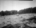
| Date: | 1898 |
|---|---|
| Description: | View from water tower, showing the grove where Black Hawk's pursuers were supposed to have camped in 1832. The group of men in the foreground are digging f... |

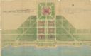
| Date: | 1792 |
|---|---|
| Description: | Map of Washington D.C. Labeled on the map are all the main streets, the site of the Capitol and the President's House. The map also shows the relationship ... |
| Date: | 07 1939 |
|---|---|
| Description: | An architectural rendering of a proposed lakefront development plan. |

| Date: | 03 27 1900 |
|---|---|
| Description: | Elevated view over Langdon Street towards the State Historical Society building, which is near completion. Written across the bottom (in reverse): "Mar. 27... |

| Date: | 1911 |
|---|---|
| Description: | View towards a construction site, with men working by a railway track with sand haulers, and a brick viaduct. Location identified as the fill and reconstru... |
| Date: | 1898 |
|---|---|
| Description: | Elevated view across Langdon Street of the Wisconsin State Historical Society building under construction in winter with snow on the ground. A group of men... |

| Date: | 1903 |
|---|---|
| Description: | Two men are standing and posing beside the cornerstone of the Eau Claire Public Library. A third man is standing on the far left just above and behind the ... |

| Date: | 1769 |
|---|---|
| Description: | Map of New Orleans at the start of the French & Indian War, including two inset maps of the Mississippi River Delta and Fort la Balise. It shows streets, r... |

| Date: | 1761 |
|---|---|
| Description: | Map of New Orleans with north oriented towards the upper right corner. It shows the land around the city, the Mississippi River, anchorages, roads leading ... |
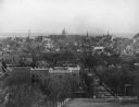
| Date: | |
|---|---|
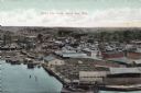
| Description: | Bird's-eye view of Green Bay from the waterfront, with commercial buildings and factories. Caption reads: "Bird's Eye View, Green Bay, Wis." |
If you didn't find the material you searched for, our Library Reference Staff can help.
Call our reference desk at 608-264-6535 or email us at: