 Filter: Categories of Wisconsin Historical Images
Filter: Subject of Building sites
Filter: Subject of forests and forestry
Filter: Categories of Wisconsin Historical Images
Filter: Subject of Building sites
Filter: Subject of forests and forestry
| Date: | 08 01 1908 |
|---|---|
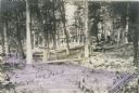
| Description: | Site in a forest of a mill, a log pond, and a dam. The location of the mill, pond and dam are sketched on the photograph. |
| Date: | |
|---|---|
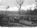
| Description: | View of the process of building a levee, including many horses and people. Caption reads: "Building the Levee near Port Gibson, Miss." |

| Date: | 1907 |
|---|---|
| Description: | Elevated view of the construction site of a dam across a river. Identified as the construction of the Hatfield dam across the Black River in 1907 to 1909. |

| Date: | 1950 |
|---|---|
| Description: | Aerial view of the camp, including a numbered index of the buildings. Used as an application form for a forestry workshop. Founded in 1944, located at 519 ... |

| Date: | 1769 |
|---|---|
| Description: | Map of New Orleans at the start of the French & Indian War, including two inset maps of the Mississippi River Delta and Fort la Balise. It shows streets, r... |

| Date: | 1761 |
|---|---|
| Description: | Map of New Orleans with north oriented towards the upper right corner. It shows the land around the city, the Mississippi River, anchorages, roads leading ... |
If you didn't find the material you searched for, our Library Reference Staff can help.
Call our reference desk at 608-264-6535 or email us at: