 Filter: Categories of Wisconsin Historical Images
Filter: Subject of Building sites
Filter: Subject of cities and towns
Filter: Subject of land use, urban
Filter: Categories of Wisconsin Historical Images
Filter: Subject of Building sites
Filter: Subject of cities and towns
Filter: Subject of land use, urban

| Date: | 1969 |
|---|---|
| Description: | A construction worker wearing a yellow hardhat looks up at the bottom portion of the World Trade Center. |

| Date: | 1917 |
|---|---|
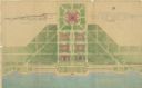
| Description: | The Lake Forest community plan, a model community that was planned for the site where the University of Wisconsin Arboretum now stands. |
| Date: | |
|---|---|
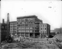
| Description: | Elevated view of west side of N. Water Street between E. Buffalo and E. Chicago Streets, featuring the Joys Building, with a contruction area in foreground... |
| Date: | 1911 |
|---|---|
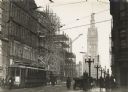
| Description: | East Water Street at Wisconsin Avenue. City Hall is in the background. At the left is the Waldheim and Company Department Store of 407-411 East Water Stree... |

| Date: | 1969 |
|---|---|
| Description: | Profile view of a man dressed in a suit and wearing a hat. He is standing in front of a large picture window, which is reflecting the framework during cons... |

| Date: | 1958 |
|---|---|
| Description: | An aerial view of the construction of a new wing on a state office building. Automobiles are parked in a log along Lake Monona. |

| Date: | 07 04 1962 |
|---|---|
| Description: | Facade detail on a State Office building being constructed at the Hill Farms Complex on University Avenue. |
| Date: | 1930 |
|---|---|
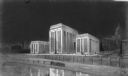
| Description: | A chalk rendering of the proposed State Office Building by State Architect, Arthur Peabody. The Wisconsin State Capitol is visible in the background. |
| Date: | 1929 |
|---|---|
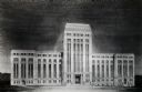
| Description: | A drawing of a State Office Building as originally proposed. |

| Date: | 1905 |
|---|---|
| Description: | A drawing by State Architect, Arthur Peabody, depicting the proposed State Street facade of the University Club building. |
| Date: | 1916 |
|---|---|
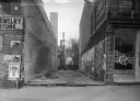
| Description: | A building site at 11 West Main Street, next to Gamm's Jewelry Store and Cop's Cafe. Power lines are in the alley in the background. |
| Date: | 11 05 1924 |
|---|---|
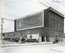
| Description: | Automobile and trucks are parked alongside the International Harvester branch building in Albany. A sign painted on the upper side of the building reads, "... |
| Date: | 1900 |
|---|---|
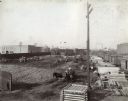
| Description: | Men use teams of horses to excavate a lot to be used as the site for the future McCormick Twine Mill. |

| Date: | 1792 |
|---|---|
| Description: | Map of Washington D.C. Labeled on the map are all the main streets, the site of the Capitol and the President's House. The map also shows the relationship ... |
| Date: | 07 1939 |
|---|---|
| Description: | An architectural rendering of a proposed lakefront development plan. |

| Date: | 03 27 1900 |
|---|---|
| Description: | Elevated view over Langdon Street towards the State Historical Society building, which is near completion. Written across the bottom (in reverse): "Mar. 27... |

| Date: | 1918 |
|---|---|
| Description: | Man in suit, holding a hat, posing on a roof across the street from the Wisconsin State Capitol, where the dome is under construction. In the far backgroun... |

| Date: | 1970 |
|---|---|
| Description: | Profile view of a man dressed in a suit and wearing a hat. He is standing in front of a large picture window, which is reflecting the framework during cons... |

| Date: | 1769 |
|---|---|
| Description: | Map of New Orleans at the start of the French & Indian War, including two inset maps of the Mississippi River Delta and Fort la Balise. It shows streets, r... |

| Date: | 1761 |
|---|---|
| Description: | Map of New Orleans with north oriented towards the upper right corner. It shows the land around the city, the Mississippi River, anchorages, roads leading ... |
If you didn't find the material you searched for, our Library Reference Staff can help.
Call our reference desk at 608-264-6535 or email us at: