 Filter: Categories of Wisconsin Historical Images
Filter: Subject of Building sites
Filter: Subject of buildings
Filter: Categories of Wisconsin Historical Images
Filter: Subject of Building sites
Filter: Subject of buildings
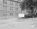
| Date: | 05 09 1946 |
|---|---|
| Description: | Site of the new Wisconsin Telephone Company central office building, to be constructed at corner of South Fairchild and West Main Streets. 16 S. Carroll St... |
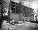
| Date: | 05 01 1931 |
|---|---|
| Description: | State Office Building, 1 W. Wilson Street, under construction. This is a side view, with two posters advertising: "10 Nights in a Barroom" at the Orpheum T... |
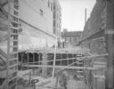
| Date: | 09 04 1929 |
|---|---|
| Description: | Addition to State Bank of Wisconsin under construction, with construction workers. 1 W. Main Street. |
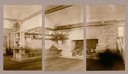
| Date: | 1911 |
|---|---|
| Description: | Triptych of the living room fireplace at Taliesin, the home of Frank Lloyd Wright. A built-in bookshelf and bench are to the left of the fireplace. The tri... |
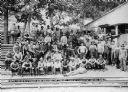
| Date: | 05 31 1912 |
|---|---|
| Description: | Workmen posing outside the dining hall before dinner. |

| Date: | 1969 |
|---|---|
| Description: | Profile view of a man dressed in a suit and wearing a hat. He is standing in front of a large picture window, which is reflecting the framework during cons... |

| Date: | 08 06 1949 |
|---|---|
| Description: | The new addition to the Wisconsin State Journal building, located at 115 South Carroll Street. The combined structures will become the plant of Madison New... |

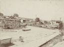
| Date: | |
|---|---|
| Description: | Exterior view of several wooden buildings under construction in a field. Identified as Vandrieul, Wisconsin. |

| Date: | 1911 |
|---|---|
| Description: | Outdoor view of a construction site, with wreckage in a ditch. Location identified as the fill and reconstruction of Town Creek after the 1911 flood in Bla... |

| Date: | 1911 |
|---|---|
| Description: | View towards a construction site, with a railway track with a train and other machinery. Location identified as the fill and reconstruction of Town Creek a... |

| Date: | 1911 |
|---|---|
| Description: | View towards a construction site, with men working by a railway track with sand haulers, and a brick viaduct. Location identified as the fill and reconstru... |

| Date: | 1911 |
|---|---|
| Description: | View towards a construction site, with people walking on a dirt road, and others working at the site. Location identified as the reconstruction following t... |

| Date: | 1911 |
|---|---|
| Description: | Elevated view of a construction site, with wreckage behind a wooden wall. Location identified as the fill and reconstruction of Town Creek after the 1911 f... |

| Date: | 11 21 1961 |
|---|---|
| Description: | "Sidewalk superintendent's" view of the excavation for the new Park Motor Inn on the Capitol Square. |

| Date: | 09 23 1965 |
|---|---|
| Description: | The new "30 on the Square" building at the corner of West Mifflin and North Carroll Street, shown almost completed. |
| Date: | 1899 |
|---|---|
| Description: | Elevated view of a horse-drawn wagon loaded with lumber standing in front of the frame of building under construction facing Main Street. There is a worker... |
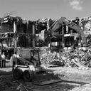
| Date: | 09 2013 |
|---|---|
| Description: | A skid steer loader is in the foreground at a demolition site, with a construction worker standing on the left surveying the site. Another construction wor... |

| Date: | 1970 |
|---|---|
| Description: | Profile view of a man dressed in a suit and wearing a hat. He is standing in front of a large picture window, which is reflecting the framework during cons... |
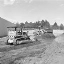
| Date: | 1971 |
|---|---|
| Description: | A man is driving a TD-20C Crawler Dozer on the left, and in the background another man is driving an H-90E Pay Loader. They are moving earth near the side ... |

| Date: | 1761 |
|---|---|
| Description: | Map of New Orleans with north oriented towards the upper right corner. It shows the land around the city, the Mississippi River, anchorages, roads leading ... |
If you didn't find the material you searched for, our Library Reference Staff can help.
Call our reference desk at 608-264-6535 or email us at: