Filter: Categories of Wisconsin Historical Images
Filter: Subject of Bridges
Filter: Year of 1900-1999
Filter: Year of 1990-1999
Filter: Categories of Wisconsin Historical Images
Filter: Subject of Bridges
Filter: Year of 1900-1999
Filter: Year of 1990-1999
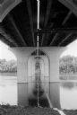
| Date: | 06 30 1992 |
|---|---|
| Description: | View from below of the Fox River Bridge. Gordon Neitzke who photographed the Fox River Bridge for the Wisconsin Department of Highways, found an almost cat... |
| Date: | 05 20 1992 |
|---|---|
| Description: | A concrete finisher stretches to trowel off a spot during construction of the Appleton Tri-County Bridge over the Fox River. |
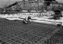
| Date: | 06 09 1992 |
|---|---|
| Description: | Close-up of rebar work on the Tri-County Fox River Bridge at Appleton, with cement finishing equipment. |
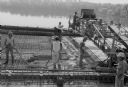
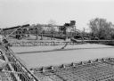
| Date: | 06 11 1992 |
|---|---|
| Description: | Employees of Lunda Concrete pour the last section of the Tri-County Fox River Bridge deck. |

| Date: | 1998 |
|---|---|
| Description: | Ile de la Cite, on the Seine River in Paris, France. |

| Date: | 1999 |
|---|---|
| Description: | The Kishwaukee River in winter and its snow-covered banks. |

| Date: | 1999 |
|---|---|
| Description: | Snow-covered bridge over the East Lagoon. |
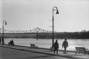
| Date: | 1998 |
|---|---|
| Description: | A couple walking along the riverfront in winter, with a bridge across the Mississippi in the background. |

| Date: | 07 1991 |
|---|---|
| Description: | "Les Beck draws water from the Rock River to water eight colorful flower boxes put up by the Theresa Lions Club." |
| Date: | 08 1995 |
|---|---|
| Description: | "A new bridge was built where Zion Church Road intersects Highway 175. The road was later relocated and now passes on the right of the farm building on th... |
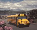
| Date: | 1990 |
|---|---|
| Description: | Color photo of an International school bus with a man in the driver's seat. The bus is in the middle of a street in a hilly residential area, with landscap... |

| Date: | 1990 |
|---|---|
| Description: | This map shows the Minnesota Point, Wisconsin Point, Hog Island, Baker's Island, Connors Point, Blatnik Bridge, Superior Bay, Allouez Bay, the Nemadji Rive... |

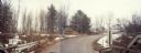
| Date: | 1993 |
|---|---|
| Description: | View from shoreline looking down at a light film of ice covering the surface of a river as it curves around a bend towards a bridge in the distance. A path... |
If you didn't find the material you searched for, our Library Reference Staff can help.
Call our reference desk at 608-264-6535 or email us at: