Filter: Categories of Wisconsin Historical Images
Filter: Subject of Bridges
Filter: Year of 1900-1999
Filter: Categories of Wisconsin Historical Images
Filter: Subject of Bridges
Filter: Year of 1900-1999
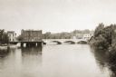
| Date: | 1905 |
|---|---|
| Description: | Elevated view of the Eau Claire River with a bridge in the background. Caption reads: "Eau Claire River, Eau Claire, Wis." |
| Date: | 1930 |
|---|---|
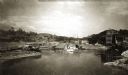
| Description: | Madison Street Bridge, built in about 1925. View from shoreline across river with the bridge on the right. |

| Date: | 1920 |
|---|---|
| Description: | Madison Street Bridge, looking east. There is a building in p the right foreground, and an industrial building in the background on the left behind the br... |
| Date: | 1900 |
|---|---|
| Description: | View up the Eau Claire River from the Dewey Street Bridge. The view shows the dam and linen mill and the site of the lower sawmill (called the "steam mill"... |
| Date: | 1910 |
|---|---|
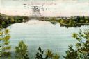
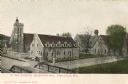
| Description: | View over bridge towards St. Paul Cathedral and Grafton Hall. Caption reads: "St Paul Cathedral and Grafton Hall, Fond du Lac, Wis." |
| Date: | 1910 |
|---|---|
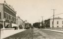
| Description: | View from center of bridge looking down Main Street, with cars and telephone lines lining both sides of the street. Caption reads: "Main St. North, Ft. Atk... |
| Date: | 1910 |
|---|---|
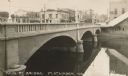
| Description: | View of a river and Main Street bridge above the river. Commercial buildings line the street on the opposite side of the bridge. Caption reads: "Main St. B... |
| Date: | 1910 |
|---|---|
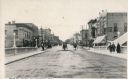
| Description: | View down center of bridge looking down Main Street, with horse-drawn carriages and people on the sidewalk. Caption reads: "Main St. South, Ft. Atkinson, W... |
| Date: | 1915 |
|---|---|
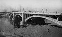
| Description: | View across water towards the Main Street Bridge over the Rock River. |
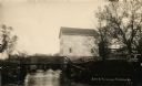
| Date: | 1914 |
|---|---|
| Description: | View of a mill on the bank of a river, and an adjacent dam. Caption at bottom reads: "Scene At Picturesque Friendship, Wis." |
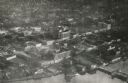
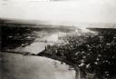
| Date: | 1920 |
|---|---|
| Description: | Aerial view of the commercial district on the east side of the Fox River. Left to right: Hurlbut Coal Company; suggested location for small terminal; Main... |
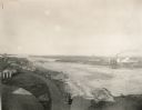
| Date: | 1924 |
|---|---|
| Description: | Aerial view of Green Bay's commercial district, bridges, and water. |
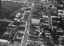
| Date: | 1920 |
|---|---|
| Description: | Aerial view with fishing piers, coal factories, a bridge, and railroad tracks. |
| Date: | 1925 |
|---|---|
| Description: | Aerial view of Green Bay, including the Jorgensen-Blesch Company building and two bridges. |
| Date: | 1920 |
|---|---|
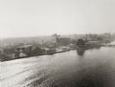
| Description: | Aerial view of with bridges, river, and shoreline. |

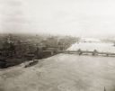
| Date: | 1950 |
|---|---|
| Description: | Aerial view of downtown and river. |
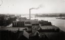
| Date: | 1910 |
|---|---|
| Description: | Elevated view over rooftops towards the Fox River looking south, with factories and a smokestack in the foreground. |
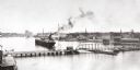
| Date: | 1910 |
|---|---|
| Description: | Slightly elevated view of the Fox River, with a bridge and ship in the river. |
If you didn't find the material you searched for, our Library Reference Staff can help.
Call our reference desk at 608-264-6535 or email us at: