 Filter: Categories of Wisconsin Historical Images
Filter: Subject of Bridges
Filter: Year of 1800-1899
Filter: Categories of Wisconsin Historical Images
Filter: Subject of Bridges
Filter: Year of 1800-1899

| Date: | 1893 |
|---|---|
| Description: | Bird's-eye map of Sturgeon Bay, looking Northeast. Area bordered by Church Street in top left corner, leather & Smith Bridge in bottom left corner, Lawrenc... |

| Date: | 1879 |
|---|---|
| Description: | Bird's-eye map of Two Rivers. |

| Date: | 1874 |
|---|---|
| Description: | Bird's-eye view of Waukesha, looking southwest, with insets of State Industrial School, Court House, and Fountain Spring House. |

| Date: | 1879 |
|---|---|
| Description: | This map is a bird's-eye view of Wausau, the County Seat of Marathon County. The map features an index of points of interest. |

| Date: | 1870 |
|---|---|
| Description: | Bird's-eye view of Whitewater, with insets. |

| Date: | 1881 |
|---|---|
| Description: | Bird's-eye view of Appleton. |

| Date: | 1854 |
|---|---|
| Description: | Bird's-eye view of Milwaukee looking east toward Lake Michigan from a bluff, long since graded into a slope, at about 6th Street between Wisconsin Avenue a... |

| Date: | 1892 |
|---|---|
| Description: | Bird's-eye view of Chicago, with ships in the Lake Michigan harbor. |
| Date: | 1889 |
|---|---|
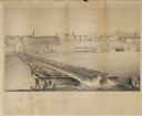
| Description: | Elevated view of bridge crossing the wide Fox River, with the paper mill on the far side of the river, and a horse-drawn cart approaching the near side. |
| Date: | 1895 |
|---|---|
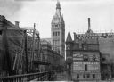
| Description: | A bridge crosses the Milwaukee River on Oneida Street, now known as Wells Street, looking toward the City Hall tower. |
| Date: | 1877 |
|---|---|
| Description: | View of the lower level of the Chicago, Milwaukee, and St. Paul railroad bridge at the Wisconsin Dells that would have been used by pedestrians and horse-d... |
| Date: | 09 22 1862 |
|---|---|
| Description: | The 22nd Regiment Wisconsin Volunteers under the command of Colonel William L. Utley, crossing the pontoon bridge at Cincinnati. |

| Date: | 05 15 1897 |
|---|---|
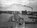
| Description: | Elevated view of the Chicago & Northwestern Railway yards looking northwest. The elevator of the Northern Grain Company is in the middle distance. |
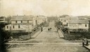
| Date: | 1895 |
|---|---|
| Description: | Elevated view down Main Street, which crosses railroad tracks in the foreground. There are two signs in the foreground which say: "Look Out for the Cars" a... |

| Date: | 1876 |
|---|---|
| Description: | View of a farmstead with fences, haystacks and a wooden outbuilding. Two men are posing on top of McCord Rock, one of them saluting with his hat. Another ... |

| Date: | 1874 |
|---|---|
| Description: | Elevated view from hill of Clinton, now Rockdale. Three men are in the middle distance, looking east across Koshonong Creek towards a mill dam, bridge and ... |
If you didn't find the material you searched for, our Library Reference Staff can help.
Call our reference desk at 608-264-6535 or email us at:


