Filter: Categories of Wisconsin Historical Images
Filter: Subject of Bridges
Filter: Year of 1800-1899
Filter: Categories of Wisconsin Historical Images
Filter: Subject of Bridges
Filter: Year of 1800-1899

| Date: | 1859 |
|---|---|
| Description: | Map featuring various views of buildings and scenes from Sauk County. |

| Date: | 1875 |
|---|---|
| Description: | View of the Sauk City bridge as seen from the Roxbury side. Two men are standing on the bridge on the far right, and buildings are behind the bridge on the... |
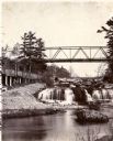
| Date: | 1885 |
|---|---|
| Description: | View looking up river towards the Kinnickinnic Falls. A bridge is above the falls. |
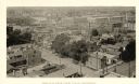
| Date: | 1888 |
|---|---|
| Description: | Elevated view from the northwest of the Racine Court House. Caption reads: "Birds-Eye from Court House, Northwest." |
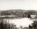
| Date: | 1869 |
|---|---|
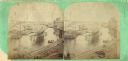
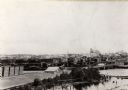
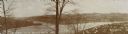
| Description: | A stereograph of an elevated view of the Root River. |
| Date: | 1885 |
|---|---|
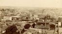
| Description: | Elevated view from tower of the Racine Court House looking north. A note at bottom center on the building of a roof reads, in part: "1st. Presby. Church. 1... |
| Date: | 1858 |
|---|---|
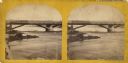
| Description: | Elevated view of the Fourth Street bridge with various buildings in the background. Caption reads: "The New Fourth Street Bridge, Racine, Wisconsin." |
| Date: | 1870 |
|---|---|
| Description: | Stereograph view of Cedar Street Bridge(?) with a rocky shoreline on the left. The construction of this bridge is the same as the Cedar Street bridge, but ... |
| Date: | 1870 |
|---|---|
| Description: | Stereograph view of the flour mill district. The Cedar Street Bridge is in the background, and the mills are, right to left going back, the Winnebago Flour... |

| Date: | 1870 |
|---|---|
| Description: | Stereograph of flour mill district. The Walnut Street bridge is in the background and the mill to the right is the Atlantic Mills (Neenah Stone Mills in 18... |
| Date: | 1890 |
|---|---|
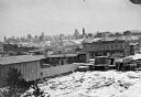
| Description: | Elevated view of the town as it appeared before the fire of 1894. |
| Date: | 1880 |
|---|---|
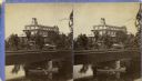
| Description: | Stereograph of the Townsend House, a resort hotel. In the foreground there are three people in a rowboat, rowing under a bridge where four other people are... |
| Date: | 1871 |
|---|---|
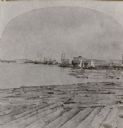
| Description: | Stereograph of a sawmill area and Lake Winnebago in the foreground. The square building with the "cupola" was the Revere House. A manuscript notation, very... |

| Date: | 1880 |
|---|---|
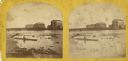
| Description: | Man in canoe close to shoreline with a bridge in the background. |

| Date: | 1870 |
|---|---|
| Description: | Stereograph of Main Street viewed from the bridge. The Revere House is just beyond the bridge on the right, and on the left is a sign on the side of a buil... |

| Date: | 1870 |
|---|---|
| Description: | Stereograph of an elevated view of the Main Street bridge, looking toward a section of the city known locally as Brooklyn. |
| Date: | 1876 |
|---|---|
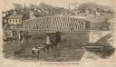
| Description: | Town and business district, showing the early covered bridge across from the tail race of the powerhouse, with logs overflowing the river into yards, proba... |
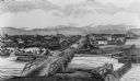
| Date: | 1894 |
|---|---|
| Description: | Panoramic view of Rochester and the Beaver Valley. Junction of the Beaver River and the Ohio River. Settlements and multiple bridges are in the background. |
If you didn't find the material you searched for, our Library Reference Staff can help.
Call our reference desk at 608-264-6535 or email us at: