 Filter: Categories of Wisconsin Historical Images
Filter: Subject of Bridges
Filter: Year of 1800-1899
Filter: Subject of rivers
Filter: Categories of Wisconsin Historical Images
Filter: Subject of Bridges
Filter: Year of 1800-1899
Filter: Subject of rivers

| Date: | 09 1871 |
|---|---|
| Description: | Bird's-eye view of Peshtigo, before it was destroyed by fire on the night of October 8, 1871. |

| Date: | 1881 |
|---|---|
| Description: | Bird's-eye map of Marinette, with insets. |
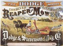
| Date: | 1871 |
|---|---|
| Description: | Advertising poster for the Dodge improved combined self raking reaper and mower featuring a color illustration of a well-dressed farmer on the machine pull... |

| Date: | 1870 |
|---|---|
| Description: | During the War of 1812, the only battle fought in Wisconsin was in Prairie du Chien, in 1814. Made fifty-six years later, this birds eye drawing depicts th... |

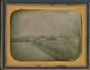
| Date: | 1855 |
|---|---|
| Description: | Quarter plate daguerreotype of the Oshkosh harbor, showing the bridge over the Fox River and several moored sailing vessels. |
| Date: | 1855 |
|---|---|
| Description: | Half plate daguerreotype, with view across water of the Oshkosh, Wisconsin harbor showing the bridge over the Fox River. Moored on the opposite shore are t... |
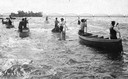
| Date: | 07 16 1898 |
|---|---|
| Description: | A group of Ojibwa men fishing from boats. |

| Date: | 1867 |
|---|---|
| Description: | Birds-eye drawing of Appleton, Outagamie Co., depicting street names and street layout, houses, the Fox River, the court house, jail, school houses, Lawren... |
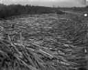
| Date: | 1895 |
|---|---|
| Description: | Logs move down the river, swirling with cross currents, resulting in a huge log jam. |

| Date: | 1890 |
|---|---|
| Description: | Bird's-eye map of Beloit with insets of Williams Engine Works, Eclipse Wind Engine Co., and John Foster & Co. Turtle Creek is in the lower section, and the... |

| Date: | 1868 |
|---|---|
| Description: | This 1868 birds-eye view depicts the buildings, streets, railroad, vegetation and topography of Columbus, Wisconsin. The high school, cemetery, railroad de... |

| Date: | 1884 |
|---|---|
| Description: | Bird's-eye map of Delavan with inset of the State Institute for Deaf and Dumb. |

| Date: | 1867 |
|---|---|
| Description: | Bird's-eye map of Green Bay and Fort Howard, Brown Co., depicts street names and street layouts, houses, trees, and the East River. A reference key at the ... |

| Date: | 1885 |
|---|---|
| Description: | Bird's-eye map of Oconomowoc. |

| Date: | 1867 |
|---|---|
| Description: | Bird's-eye view of Oshkosh, "drawn from nature." |

| Date: | 1885 |
|---|---|
| Description: | Bird's-eye view of Sheboygan, with inset of J.J. Volrath Manufacturing Company. |

| Date: | 1872 |
|---|---|
| Description: | Bird's-eye map of Milwaukee on Lake Michigan. |

| Date: | 1875 |
|---|---|
| Description: | Bird's-eye map of Black River Falls, looking southwest. |

| Date: | 1882 |
|---|---|
| Description: | This map of Cedarburg is a bird's-eye map with an inset of Cedarburg Brewery. Relief is shown pictorially and the map includes an index to buildings. |
If you didn't find the material you searched for, our Library Reference Staff can help.
Call our reference desk at 608-264-6535 or email us at:
