 Filter: Categories of Wisconsin Historical Images
Filter: Subject of Bridges
Filter: Subject of marshes
Filter: Categories of Wisconsin Historical Images
Filter: Subject of Bridges
Filter: Subject of marshes

| Date: | 1867 |
|---|---|
| Description: | Bird's-eye map of Green Bay and Fort Howard, Brown Co., depicts street names and street layouts, houses, trees, and the East River. A reference key at the ... |

| Date: | 1873 |
|---|---|
| Description: | A map that covers parts of Winona and Houston Counties, Minnesota and La Crosse County, Wisconsin, showing the proposed railroad routes, constructed rail l... |
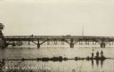
| Date: | |
|---|---|
| Description: | View from shore towards a bridge crossing a river. Three boys are standing in the marshy foreground, and one of them has a fishing pole. A horse and buggy ... |

| Date: | 11 1781 |
|---|---|
| Description: | Map of New York, Staten Island, and Long Island, showing the placements of forts, and the movement of troops in 1776. The map also includes towns, cities, ... |

| Date: | 1781 |
|---|---|
| Description: | Map of North and South Carolina and Virginia towards the end of the Revolutionary War. It shows borders, counties, cities, court houses, bridges, chapels, ... |

| Date: | 09 18 2014 |
|---|---|
| Description: | View from a bridge looking down at the shadow of the photographer on the surface of the Sugar River. |

| Date: | 1905 |
|---|---|
| Description: | View from shoreline looking towards two women wearing large hats who are sitting in a carriage drawn by a matched team of horses. The carriage has stopped ... |
If you didn't find the material you searched for, our Library Reference Staff can help.
Call our reference desk at 608-264-6535 or email us at: