 Filter: Categories of Wisconsin Historical Images
Filter: Subject of Bridges
Filter: Subject of indian reservations
Filter: Categories of Wisconsin Historical Images
Filter: Subject of Bridges
Filter: Subject of indian reservations
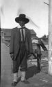
| Date: | 1913 |
|---|---|
| Description: | Portrait of Chippewa (Ojibwa) man at Bad River Indian Reservation. |

| Date: | 1950 |
|---|---|
| Description: | This road map shows federal, state and county roads in Wisconsin, northern Illinois, northeastern Iowa, eastern Minnesota, and the western portion of Michi... |

| Date: | 1897 |
|---|---|
| Description: | This 1897 map of Sawyer County, Wisconsin, shows the township and range system, sections, roads, farm houses, camps, school houses, dams, bridges, Indian r... |

| Date: | 1902 |
|---|---|
| Description: | This 1902 map of the eastern portion of Sawyer County, Wisconsin, shows the township and range system, sections, roads, farm houses, camps, school houses, ... |
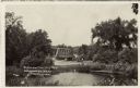
| Date: | |
|---|---|
| Description: | View over water towards a road leading to a bridge. A man is standing next to an automobile on the side of the road. |
If you didn't find the material you searched for, our Library Reference Staff can help.
Call our reference desk at 608-264-6535 or email us at: