 Filter: Categories of Wisconsin Historical Images
Filter: Subject of Bridges
Filter: Subject of human settlements
Filter: Subject of universities and colleges
Filter: Categories of Wisconsin Historical Images
Filter: Subject of Bridges
Filter: Subject of human settlements
Filter: Subject of universities and colleges

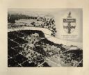
| Date: | 1867 |
|---|---|
| Description: | Birds-eye drawing of Appleton, Outagamie Co., depicting street names and street layout, houses, the Fox River, the court house, jail, school houses, Lawren... |

| Date: | 1927 |
|---|---|
| Description: | Color map, hand-drawn with comic figures engaged in various activities throughout map. Bordered by the river on the left and Lake Michigan on the right, in... |

| Date: | 1874 |
|---|---|
| Description: | Bird's-eye map of Racine, with an inset of Racine College. |
| Date: | 1942 |
|---|---|
| Description: | Trees interspersed with college buildings in lower half of image, with Fox River bisecting the middle, and a few buildings across the river with open fiel... |
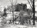
| Date: | 1955 |
|---|---|
| Description: | Wheeler Hall at Northland College, during winter. A group of people are on a bridge over the Bay City Creek, surrounded by trees, in the foreground. Wheele... |
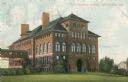
| Date: | 1905 |
|---|---|
| Description: | The Central School building is attached to the Bowman Building by a second-story bridge on the left. Caption reads: "Central School Menomonie, Wis." |

| Date: | |
|---|---|
| Description: | Plat map of the east central part of the city. |

| Date: | |
|---|---|
| Description: | Bird's-eye view of the north branch extension canal on the Susquehanna river, surrounded by smaller renderings of structures of interest around the town in... |
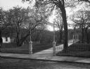
| Date: | |
|---|---|
| Description: | A view of the entrance and foot bridge to the campus at State Normal School. A wrought iron gate surrounds the property, and a metalwork banner over the en... |
If you didn't find the material you searched for, our Library Reference Staff can help.
Call our reference desk at 608-264-6535 or email us at: